Longzhouping geodata
Longzhouping (Hubei) is a seat of a fourth-order administrative division; located in China in Asia/Shanghai (GMT+8) time zone. In our database, there are 1268 cities with bigger population. Compared to other cities in China, 50.3% of cities are located further ↓South; 66.4% of cities are located further →East and 60.3% of cities have higher elevation than Longzhouping. Note1


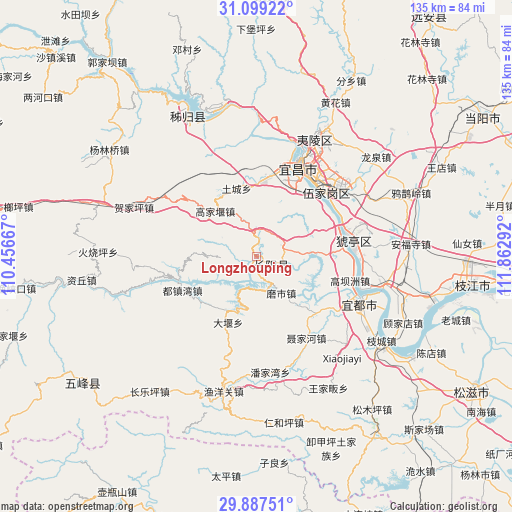
Longzhouping GPS coordinates[2]
30° 29' 42.9" North, 111° 9' 35.244" East
| Map corner | latitude | longitude |
|---|---|---|
| Upper-left | 31.09922°, | 110.45667° |
| Center: | 30.49525°, | 111.15979° |
| Lower-right: | 29.88751°, | 111.86292° |
| Map W x H: | 134.7×134.7 km | = 83.7×83.7mi |
| max Lat: | 53.31946° ⇑49.7% North |
| Longzhouping: | 30.49525° |
| min Lat: | ⇓50.3% South 18.22056° |
| min Long | Longzhouping | max Long |
| 75.07348° | 111.15979° | 134.28917° |
| W 33.6%⇐ | ⇒66.4% E |
Elevation
Elevation of Longzhouping is 97 m = 318 ft, and this is 387.8 m = 1272 ft below average elevation for this country.
| Max E: |
5622 m = 18445 ft | 60.3% |
| Avg. | 484.8 m = 1591 ft | |
| Longzhouping | 97 m = 318 ft | |
Min E: |
-3 m = -10 ft | 39.7% |
See also: China elevation on elevation.city.
Geographical zone
Longzhouping is located in North temperate zone (between Tropic of Cancer and the Arctic Circle). Distance of this Northern Tropic circle is 784.8 km =487.7 mi to South.| Distance of | km | miles | from Longzhouping |
|---|---|---|---|
| North Pole | 6616.3 | 4111.2 | to North |
| Arctic Circle | 4010.4 | 2491.9 | to North |
| Tropic Cancer | 784.8 | 487.7 | to South |
| Equator | 3390.8 | 2106.9 | to South |


Nearby cities:
15 places around Longzhouping: (largest is in red/bold)
• Aijia
22.8 km =14.2 mi,  51°
51°
• Dayan
18.8 km =11.7 mi,  202°
202°
• Dianjun
24.9 km =15.5 mi,  22°
22°
• Duzhenwan
21.3 km =13.2 mi,  245°
245°
• Gaojiayan
16.1 km =10 mi,  321°
321°
• Honghuatao
23.4 km =14.5 mi,  84°
84°
• Huya
24.1 km =15 mi,  69°
69°
• Lianpeng
20.6 km =12.8 mi,  30°
30°
• Moshi
11.7 km =7.3 mi,  139°
139°
• Niejiahe
24.9 km =15.5 mi,  148°
148°
• Qiaobian
21 km =13 mi,  7°
7°
• Tucheng
18.6 km =11.6 mi,  344°
344°
• Wujia
24.6 km =15.3 mi, 46°
• Wuyanquan
22 km =13.7 mi, 135°
• Yazikou
23 km =14.3 mi,  256°
256°
Sources, notices
• [Note1] Compared only with cities in China existing in our database
• [Src1] Map data: © OpenStreetMap contributors (CC-BY-SA)
• [Src2] Other city data from geonames.org with taken over terms of usage.
• [Src3] Geographical zone / Annual Mean Temperature by Robert A. Rohde @ Wikipedia
