Dayan geodata
Dayan (Hubei) is a seat of a fourth-order administrative division; located in China in Asia/Shanghai (GMT+8) time zone. In our database, there are 1268 cities with bigger population. Compared to other cities in China, 50.9% of cities are located further ↑North; 66.7% of cities are located further →East and 78% of cities have lower elevation than Dayan. Note1


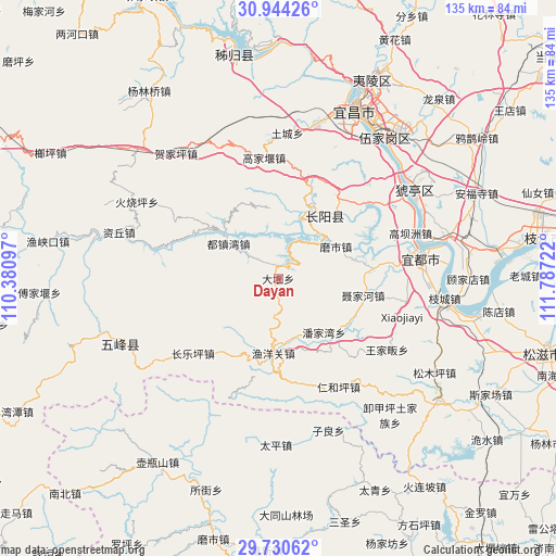
Dayan GPS coordinates[2]
30° 20' 21.552" North, 111° 5' 2.724" East
| Map corner | latitude | longitude |
|---|---|---|
| Upper-left | 30.94426°, | 110.38097° |
| Center: | 30.33932°, | 111.08409° |
| Lower-right: | 29.73062°, | 111.78722° |
| Map W x H: | 134.9×134.9 km | = 83.8×83.8mi |
| max Lat: | 53.31946° ⇑50.9% North |
| Dayan: | 30.33932° |
| min Lat: | ⇓49.1% South 18.22056° |
| min Long | Dayan | max Long |
| 75.07348° | 111.08409° | 134.28917° |
| W 33.3%⇐ | ⇒66.7% E |
Elevation
Elevation of Dayan is 615 m = 2018 ft, and this is 130.2 m = 427 ft above average elevation for this country.
| Max E: |
5622 m = 18445 ft | 22% |
| Dayan | 615 m 2018 ft | |
| Avg. | 484.8 m = 1591 ft | |
Min E: |
-3 m = -10 ft | 78% |
See also: China elevation on elevation.city.
Geographical zone
Dayan is located in North temperate zone (between Tropic of Cancer and the Arctic Circle). Distance of this Northern Tropic circle is 767.5 km =476.9 mi to South.| Distance of | km | miles | from Dayan |
|---|---|---|---|
| North Pole | 6633.6 | 4121.9 | to North |
| Arctic Circle | 4027.8 | 2502.8 | to North |
| Tropic Cancer | 767.5 | 476.9 | to South |
| Equator | 3373.4 | 2096.1 | to South |


Nearby cities:
15 places around Dayan: (largest is in red/bold)
• Changleping
27.6 km =17.1 mi,  228°
228°
• Duzhenwan
14.7 km =9.1 mi,  304°
304°
• Gaobazhou
33.9 km =21.1 mi,  71°
71°
• Gaojiayan
30.1 km =18.7 mi,  354°
354°
• Longzhouping
18.8 km =11.7 mi,  22°
22°
• Moshi
17 km =10.6 mi,  60°
60°
• Niejiahe
20.7 km =12.9 mi,  100°
100°
• Panjiawan
17.2 km =10.7 mi,  139°
139°
• Renheping
30.2 km =18.8 mi,  150°
150°
• Tucheng
35.3 km =21.9 mi,  3°
3°
• Wangjiafan
31.7 km =19.7 mi,  123°
123°
• Wuyanquan
22.9 km =14.2 mi,  85°
85°
• Yaojiadian
34.1 km =21.2 mi,  84°
84°
• Yazikou
19.2 km =11.9 mi,  308°
308°
• Yuyangguan
18.2 km =11.3 mi,  184°
184°
Sources, notices
• [Note1] Compared only with cities in China existing in our database
• [Src1] Map data: © OpenStreetMap contributors (CC-BY-SA)
• [Src2] Other city data from geonames.org with taken over terms of usage.
• [Src3] Geographical zone / Annual Mean Temperature by Robert A. Rohde @ Wikipedia
