Liulin geodata
Liulin (Shaanxi) is a seat of a fourth-order administrative division; located in China in Asia/Shanghai (GMT+8) time zone. In our database, there are 1268 cities with bigger population. Compared to other cities in China, 73% of cities are located further ↓South; 82.8% of cities are located further →East and 82.8% of cities have lower elevation than Liulin. Note1


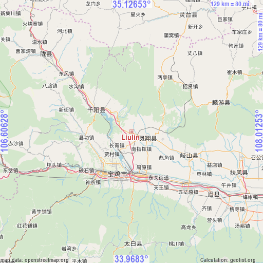
Liulin GPS coordinates[2]
34° 32' 57.948" North, 107° 18' 33.84" East
| Map corner | latitude | longitude |
|---|---|---|
| Upper-left | 35.12653°, | 106.60628° |
| Center: | 34.54943°, | 107.3094° |
| Lower-right: | 33.9683°, | 108.01253° |
| Map W x H: | 128.8×128.8 km | = 80×80mi |
| max Lat: | 53.31946° ⇑27% North |
| Liulin: | 34.54943° |
| min Lat: | ⇓73% South 18.22056° |
| min Long | Liulin | max Long |
| 75.07348° | 107.3094° | 134.28917° |
| W 17.2%⇐ | ⇒82.8% E |
Elevation
Elevation of Liulin is 837 m = 2746 ft, and this is 352.2 m = 1156 ft above average elevation for this country.
| Max E: |
5622 m = 18445 ft | 17.2% |
| Liulin | 837 m 2746 ft | |
| Avg. | 484.8 m = 1591 ft | |
Min E: |
-3 m = -10 ft | 82.8% |
See also: China elevation on elevation.city.
Geographical zone
Liulin is located in North temperate zone (between Tropic of Cancer and the Arctic Circle). Distance of this Northern Tropic circle is 1235.6 km =767.8 mi to South.| Distance of | km | miles | from Liulin |
|---|---|---|---|
| North Pole | 6165.5 | 3831.1 | to North |
| Arctic Circle | 3559.6 | 2211.8 | to North |
| Tropic Cancer | 1235.6 | 767.8 | to South |
| Equator | 3841.5 | 2387 | to South |


Nearby cities:
15 places around Liulin: (largest is in red/bold)
• Cuijiatou
12 km =7.5 mi,  323°
323°
• Dongjiahe
6.1 km =3.8 mi,  48°
48°
• Fanjiazhai
9.8 km =6.1 mi,  56°
56°
• Fengxiang Chengguanzhen
8.1 km =5 mi,  111°
111°
• Guodian
14.8 km =9.2 mi,  134°
134°
• Hanfeng
7.8 km =4.8 mi,  351°
351°
• Jiacun
14.4 km =8.9 mi,  221°
221°
• Meiganqiao
13 km =8.1 mi,  93°
93°
• Nanzhai
17.3 km =10.7 mi,  313°
313°
• Nanzhihui
9.7 km =6 mi,  154°
154°
• Qianhe
17.3 km =10.7 mi,  182°
182°
• Qiaozhen
17.1 km =10.6 mi,  245°
245°
• Shajia’ao
15.5 km =9.6 mi,  332°
332°
• Tangcun
2.7 km =1.7 mi, 182°
• Tianjiazhuang
15.7 km =9.8 mi,  104°
104°
Sources, notices
• [Note1] Compared only with cities in China existing in our database
• [Src1] Map data: © OpenStreetMap contributors (CC-BY-SA)
• [Src2] Other city data from geonames.org with taken over terms of usage.
• [Src3] Geographical zone / Annual Mean Temperature by Robert A. Rohde @ Wikipedia
