Liubo geodata
Liubo (Hunan) is a seat of a fourth-order administrative division; located in China in Asia/Shanghai (GMT+8) time zone. In our database, there are 1268 cities with bigger population. Compared to other cities in China, 72.2% of cities are located further ↑North; 74.1% of cities are located further →East and 81% of cities have lower elevation than Liubo. Note1


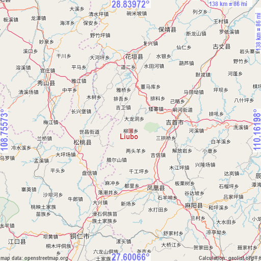
Liubo GPS coordinates[2]
28° 13' 19.164" North, 109° 27' 31.86" East
| Map corner | latitude | longitude |
|---|---|---|
| Upper-left | 28.83972°, | 108.75573° |
| Center: | 28.22199°, | 109.45885° |
| Lower-right: | 27.60066°, | 110.16198° |
| Map W x H: | 137.8×137.8 km | = 85.6×85.6mi |
| max Lat: | 53.31946° ⇑72.2% North |
| Liubo: | 28.22199° |
| min Lat: | ⇓27.8% South 18.22056° |
| min Long | Liubo | max Long |
| 75.07348° | 109.45885° | 134.28917° |
| W 25.9%⇐ | ⇒74.1% E |
Elevation
Elevation of Liubo is 744 m = 2441 ft, and this is 259.2 m = 850 ft above average elevation for this country.
| Max E: |
5622 m = 18445 ft | 19% |
| Liubo | 744 m 2441 ft | |
| Avg. | 484.8 m = 1591 ft | |
Min E: |
-3 m = -10 ft | 81% |
See also: China elevation on elevation.city.
Geographical zone
Liubo is located in North temperate zone (between Tropic of Cancer and the Arctic Circle). Distance of this Northern Tropic circle is 532.1 km =330.6 mi to South.| Distance of | km | miles | from Liubo |
|---|---|---|---|
| North Pole | 6869.1 | 4268.3 | to North |
| Arctic Circle | 4263.2 | 2649 | to North |
| Tropic Cancer | 532.1 | 330.6 | to South |
| Equator | 3138 | 1949.9 | to South |


Nearby cities:
15 places around Liubo: (largest is in red/bold)
• Aizhai
17.6 km =10.9 mi,  48°
48°
• Buchou
8.7 km =5.4 mi,  334°
334°
• Dalongdong
6.6 km =4.1 mi,  15°
15°
• Datian
15.3 km =9.5 mi,  130°
130°
• Heku
4.1 km =2.5 mi,  160°
160°
• Huoluping
10.2 km =6.3 mi,  149°
149°
• Jiwei
13 km =8.1 mi,  342°
342°
• La’ershan
17 km =10.6 mi,  206°
206°
• Lianglin
10.2 km =6.3 mi,  225°
225°
• Liangtouyang
10.9 km =6.8 mi,  165°
165°
• Miliang
5.4 km =3.4 mi,  63°
63°
• Paiwu
16.7 km =10.4 mi, 343°
• Panshi
16.1 km =10 mi,  269°
269°
• Shetangpo
13.7 km =8.5 mi,  86°
86°
• Yaxi
8.5 km =5.3 mi,  254°
254°
Sources, notices
• [Note1] Compared only with cities in China existing in our database
• [Src1] Map data: © OpenStreetMap contributors (CC-BY-SA)
• [Src2] Other city data from geonames.org with taken over terms of usage.
• [Src3] Geographical zone / Annual Mean Temperature by Robert A. Rohde @ Wikipedia
