Miliang geodata
Miliang (Hunan) is a seat of a fourth-order administrative division; located in China in Asia/Shanghai (GMT+8) time zone. In our database, there are 1268 cities with bigger population. Compared to other cities in China, 72% of cities are located further ↑North; 73.8% of cities are located further →East and 79.5% of cities have lower elevation than Miliang. Note1


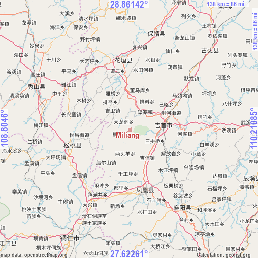
Miliang GPS coordinates[2]
28° 14' 37.716" North, 109° 30' 27.792" East
| Map corner | latitude | longitude |
|---|---|---|
| Upper-left | 28.86142°, | 108.8046° |
| Center: | 28.24381°, | 109.50772° |
| Lower-right: | 27.62261°, | 110.21085° |
| Map W x H: | 137.7×137.7 km | = 85.6×85.6mi |
| max Lat: | 53.31946° ⇑72% North |
| Miliang: | 28.24381° |
| min Lat: | ⇓28% South 18.22056° |
| min Long | Miliang | max Long |
| 75.07348° | 109.50772° | 134.28917° |
| W 26.2%⇐ | ⇒73.8% E |
Elevation
Elevation of Miliang is 671 m = 2201 ft, and this is 186.2 m = 611 ft above average elevation for this country.
| Max E: |
5622 m = 18445 ft | 20.5% |
| Miliang | 671 m 2201 ft | |
| Avg. | 484.8 m = 1591 ft | |
Min E: |
-3 m = -10 ft | 79.5% |
See also: China elevation on elevation.city.
Geographical zone
Miliang is located in North temperate zone (between Tropic of Cancer and the Arctic Circle). Distance of this Northern Tropic circle is 534.5 km =332.1 mi to South.| Distance of | km | miles | from Miliang |
|---|---|---|---|
| North Pole | 6866.6 | 4266.7 | to North |
| Arctic Circle | 4260.8 | 2647.5 | to North |
| Tropic Cancer | 534.5 | 332.1 | to South |
| Equator | 3140.4 | 1951.4 | to South |


Nearby cities:
15 places around Miliang: (largest is in red/bold)
• Aizhai
12.5 km =7.8 mi,  42°
42°
• Buchou
10.1 km =6.3 mi,  302°
302°
• Dalongdong
4.9 km =3 mi,  322°
322°
• Datian
14.2 km =8.8 mi,  151°
151°
• Ganziping
15.2 km =9.4 mi,  109°
109°
• Heku
7.2 km =4.5 mi,  208°
208°
• Huoluping
11.2 km =7 mi,  178°
178°
• Jiwei
13.3 km =8.3 mi, 318°
• Lianglin
15.5 km =9.6 mi,  231°
231°
• Liangtouyang
13.1 km =8.1 mi,  189°
189°
• Liubo
5.4 km =3.4 mi,  243°
243°
• Paibi
15.7 km =9.8 mi,  9°
9°
• Sangongqiao
15.1 km =9.4 mi, 114°
• Shetangpo
9.1 km =5.7 mi,  100°
100°
• Yaxi
13.8 km =8.6 mi,  249°
249°
Sources, notices
• [Note1] Compared only with cities in China existing in our database
• [Src1] Map data: © OpenStreetMap contributors (CC-BY-SA)
• [Src2] Other city data from geonames.org with taken over terms of usage.
• [Src3] Geographical zone / Annual Mean Temperature by Robert A. Rohde @ Wikipedia
