Lintou geodata
Lintou (Guangdong) is a seat of a fourth-order administrative division; located in China in Asia/Urumqi (GMT+6) time zone. In our database, there are 1268 cities with bigger population. Compared to other cities in China, 97.8% of cities are located further ↑North; 66.8% of cities are located further →East and 81.6% of cities have higher elevation than Lintou. Note1


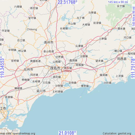
Lintou GPS coordinates[2]
21° 39' 56.592" North, 111° 2' 55.14" East
| Map corner | latitude | longitude |
|---|---|---|
| Upper-left | 22.31768°, | 110.34553° |
| Center: | 21.66572°, | 111.04865° |
| Lower-right: | 21.0108°, | 111.75178° |
| Map W x H: | 145.3×145.3 km | = 90.3×90.3mi |
| max Lat: | 53.31946° ⇑97.8% North |
| Lintou: | 21.66572° |
| min Lat: | ⇓2.2% South 18.22056° |
| min Long | Lintou | max Long |
| 75.07348° | 111.04865° | 134.28917° |
| W 33.2%⇐ | ⇒66.8% E |
Elevation
Elevation of Lintou is 23 m = 75 ft, and this is 461.8 m = 1515 ft below average elevation for this country.
| Max E: |
5622 m = 18445 ft | 81.6% |
| Avg. | 484.8 m = 1591 ft | |
| Lintou | 23 m = 75 ft | |
Min E: |
-3 m = -10 ft | 18.4% |
See also: China elevation on elevation.city.
Geographical zone
Lintou is located in North Torrid zone (between Equator and Tropic of Cancer). Distance of this Northern Tropic circle is 196.9 km =122.3 mi to North.| Distance of | km | miles | from Lintou |
|---|---|---|---|
| North Pole | 7598.1 | 4721.2 | to North |
| Arctic Circle | 4992.2 | 3102 | to North |
| Tropic Cancer | 196.9 | 122.3 | to North |
| Equator | 2409 | 1496.9 | to South |


Nearby cities:
15 places around Lintou: (largest is in red/bold)
• Fenjie
14.8 km =9.2 mi,  323°
323°
• Gaoshan
15.6 km =9.7 mi,  265°
265°
• Genzi
14.9 km =9.3 mi,  356°
356°
• Guandu
13.5 km =8.4 mi,  276°
276°
• Guanzhu
13.2 km =8.2 mi,  77°
77°
• Hedong
12.5 km =7.8 mi, 270°
• Hexi
15.4 km =9.6 mi, 276°
• Maoming
15.5 km =9.6 mi,  263°
263°
• Meihua
15.2 km =9.4 mi,  230°
230°
• Poxin
5.3 km =3.3 mi,  239°
239°
• Qijing
12.2 km =7.6 mi,  207°
207°
• Shange
14.2 km =8.8 mi,  299°
299°
• Xiadong
9.8 km =6.1 mi,  40°
40°
• Xinpo
16.1 km =10 mi, 268°
• Yangjiao
6.8 km =4.2 mi, 281°
Sources, notices
• [Note1] Compared only with cities in China existing in our database
• [Src1] Map data: © OpenStreetMap contributors (CC-BY-SA)
• [Src2] Other city data from geonames.org with taken over terms of usage.
• [Src3] Geographical zone / Annual Mean Temperature by Robert A. Rohde @ Wikipedia
