Meihua geodata
Meihua (Guangdong) is a seat of a fourth-order administrative division; located in China in Asia/Urumqi (GMT+6) time zone. In our database, there are 1268 cities with bigger population. Compared to other cities in China, 98% of cities are located further ↑North; 67.3% of cities are located further →East and 87.7% of cities have higher elevation than Meihua. Note1


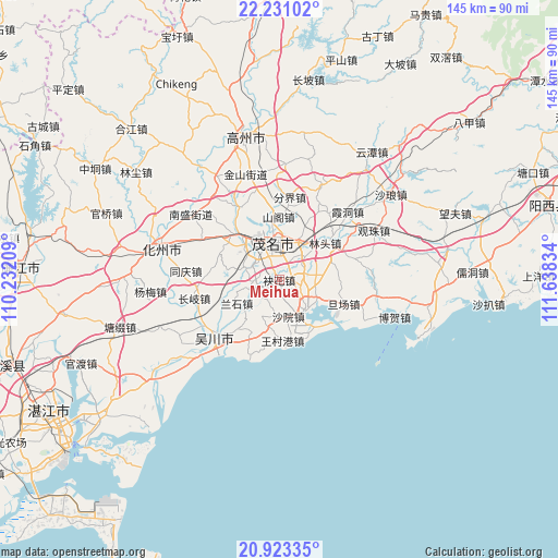
Meihua GPS coordinates[2]
21° 34' 43.176" North, 110° 56' 6.756" East
| Map corner | latitude | longitude |
|---|---|---|
| Upper-left | 22.23102°, | 110.23209° |
| Center: | 21.57866°, | 110.93521° |
| Lower-right: | 20.92335°, | 111.63834° |
| Map W x H: | 145.4×145.4 km | = 90.3×90.3mi |
| max Lat: | 53.31946° ⇑98% North |
| Meihua: | 21.57866° |
| min Lat: | ⇓2% South 18.22056° |
| min Long | Meihua | max Long |
| 75.07348° | 110.93521° | 134.28917° |
| W 32.7%⇐ | ⇒67.3% E |
Elevation
Elevation of Meihua is 12 m = 39 ft, and this is 472.8 m = 1551 ft below average elevation for this country.
| Max E: |
5622 m = 18445 ft | 87.7% |
| Avg. | 484.8 m = 1591 ft | |
| Meihua | 12 m = 39 ft | |
Min E: |
-3 m = -10 ft | 12.3% |
See also: China elevation on elevation.city.
Geographical zone
Meihua is located in North Torrid zone (between Equator and Tropic of Cancer). Distance of this Northern Tropic circle is 206.6 km =128.4 mi to North.| Distance of | km | miles | from Meihua |
|---|---|---|---|
| North Pole | 7607.7 | 4727.2 | to North |
| Arctic Circle | 5001.9 | 3108 | to North |
| Tropic Cancer | 206.6 | 128.4 | to North |
| Equator | 2399.3 | 1490.9 | to South |


Nearby cities:
15 places around Meihua: (largest is in red/bold)
• Aotou
8.5 km =5.3 mi,  250°
250°
• Gaodi
10.3 km =6.4 mi,  150°
150°
• Gaoshan
9.2 km =5.7 mi,  335°
335°
• Guandu
11.3 km =7 mi,  351°
351°
• Hedong
9.9 km =6.2 mi,  355°
355°
• Hexi
12 km =7.5 mi, 342°
• Lanshi
13.2 km =8.2 mi,  238°
238°
• Maoming
8.7 km =5.4 mi, 335°
• Poxin
10 km =6.2 mi,  45°
45°
• Qijing
6.2 km =3.9 mi,  100°
100°
• Shuidong
10 km =6.2 mi,  136°
136°
• Xiaoliang
10.6 km =6.6 mi,  205°
205°
• Xinpo
10.2 km =6.3 mi,  334°
334°
• Yangjiao
12.1 km =7.5 mi,  24°
24°
• Zhencheng
9.6 km =6 mi,  291°
291°
Sources, notices
• [Note1] Compared only with cities in China existing in our database
• [Src1] Map data: © OpenStreetMap contributors (CC-BY-SA)
• [Src2] Other city data from geonames.org with taken over terms of usage.
• [Src3] Geographical zone / Annual Mean Temperature by Robert A. Rohde @ Wikipedia
