Linping geodata
Linping (Zhejiang) is a seat of a third-order administrative division; located in China in Asia/Shanghai (GMT+8) time zone. With population of 78,180 people, there are 546 cities with bigger population in this country. Compared to other cities in China, 50.2% of cities are located further ↑North; 83.9% of cities are located further ←West and 85.5% of cities have higher elevation than Linping. Note1


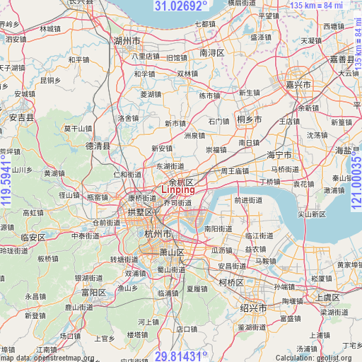
Linping GPS coordinates[2]
30° 25' 21" North, 120° 17' 49.992" East
| Map corner | latitude | longitude |
|---|---|---|
| Upper-left | 31.02692°, | 119.5941° |
| Center: | 30.4225°, | 120.29722° |
| Lower-right: | 29.81431°, | 121.00035° |
| Map W x H: | 134.8×134.8 km | = 83.8×83.8mi |
| max Lat: | 53.31946° ⇑50.2% North |
| Linping: | 30.4225° |
| min Lat: | ⇓49.8% South 18.22056° |
| min Long | Linping | max Long |
| 75.07348° | 120.29722° | 134.28917° |
| W 83.9%⇐ | ⇒16.1% E |
Elevation
Elevation of Linping is 15 m = 49 ft, and this is 469.8 m = 1541 ft below average elevation for this country.
| Max E: |
5622 m = 18445 ft | 85.5% |
| Avg. | 484.8 m = 1591 ft | |
| Linping | 15 m = 49 ft | |
Min E: |
-3 m = -10 ft | 14.5% |
See also: Linping elevation on elevation.city.
Geographical zone
Linping is located in North temperate zone (between Tropic of Cancer and the Arctic Circle). Distance of this Northern Tropic circle is 776.7 km =482.6 mi to South.| Distance of | km | miles | from Linping |
|---|---|---|---|
| North Pole | 6624.4 | 4116.2 | to North |
| Arctic Circle | 4018.5 | 2497 | to North |
| Tropic Cancer | 776.7 | 482.6 | to South |
| Equator | 3382.7 | 2101.9 | to South |


Nearby cities:
15 places around Linping: (largest is in red/bold)
• Banshan
13.9 km =8.6 mi,  235°
235°
• Chang’an
14.5 km =9 mi,  75°
75°
• Chongxian
12.7 km =7.9 mi,  252°
252°
• Dama
9.8 km =6.1 mi,  25°
25°
• Dingqiao
10.6 km =6.6 mi,  222°
222°
• Jianqiao
13.9 km =8.6 mi,  214°
214°
• Jiubao
11.9 km =7.4 mi,  194°
194°
• Qiaosi
8 km =5 mi, 188°
• Tangqi
12.7 km =7.9 mi,  299°
299°
• Xiasha
12.6 km =7.8 mi,  171°
171°
• Xingqiao
5.1 km =3.2 mi, 239°
• Xin’an
14.5 km =9 mi,  328°
328°
• Xucun
6.6 km =4.1 mi, 77°
• Yunhe
5.8 km =3.6 mi,  358°
358°
• Yuyue
11.3 km =7 mi,  342°
342°
Sources, notices
• [Note1] Compared only with cities in China existing in our database
• [Src1] Map data: © OpenStreetMap contributors (CC-BY-SA)
• [Src2] Other city data from geonames.org with taken over terms of usage.
• [Src3] Geographical zone / Annual Mean Temperature by Robert A. Rohde @ Wikipedia
