Xiasha geodata
Xiasha (Zhejiang) is a seat of a fourth-order administrative division; located in China in Asia/Shanghai (GMT+8) time zone. In our database, there are 1268 cities with bigger population. Compared to other cities in China, 51.1% of cities are located further ↑North; 84% of cities are located further ←West and 87.7% of cities have higher elevation than Xiasha. Note1


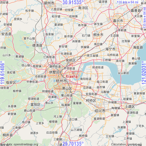
Xiasha GPS coordinates[2]
30° 18' 36.828" North, 120° 19' 1.848" East
| Map corner | latitude | longitude |
|---|---|---|
| Upper-left | 30.91535°, | 119.61406° |
| Center: | 30.31023°, | 120.31718° |
| Lower-right: | 29.70135°, | 121.02031° |
| Map W x H: | 135×135 km | = 83.9×83.9mi |
| max Lat: | 53.31946° ⇑51.1% North |
| Xiasha: | 30.31023° |
| min Lat: | ⇓48.9% South 18.22056° |
| min Long | Xiasha | max Long |
| 75.07348° | 120.31718° | 134.28917° |
| W 84%⇐ | ⇒16% E |
Elevation
Elevation of Xiasha is 12 m = 39 ft, and this is 472.8 m = 1551 ft below average elevation for this country.
| Max E: |
5622 m = 18445 ft | 87.7% |
| Avg. | 484.8 m = 1591 ft | |
| Xiasha | 12 m = 39 ft | |
Min E: |
-3 m = -10 ft | 12.3% |
See also: China elevation on elevation.city.
Geographical zone
Xiasha is located in North temperate zone (between Tropic of Cancer and the Arctic Circle). Distance of this Northern Tropic circle is 764.3 km =474.9 mi to South.| Distance of | km | miles | from Xiasha |
|---|---|---|---|
| North Pole | 6636.9 | 4124 | to North |
| Arctic Circle | 4031 | 2504.7 | to North |
| Tropic Cancer | 764.3 | 474.9 | to South |
| Equator | 3370.2 | 2094.1 | to South |


Nearby cities:
15 places around Xiasha: (largest is in red/bold)
• Banshan
14.1 km =8.8 mi,  289°
289°
• Dingqiao
10.2 km =6.3 mi,  297°
297°
• Hezhuang
13.9 km =8.6 mi,  94°
94°
• Jianqiao
9.9 km =6.2 mi,  276°
276°
• Jiubao
5 km =3.1 mi, 281°
• Linping
12.6 km =7.8 mi,  351°
351°
• Nanyang
13.1 km =8.1 mi,  113°
113°
• Ningwei
11.3 km =7 mi,  200°
200°
• Pengbu
9.5 km =5.9 mi,  257°
257°
• Qiaosi
5.5 km =3.4 mi,  326°
326°
• Sijiqing
14.4 km =8.9 mi,  241°
241°
• Xindong
13.9 km =8.6 mi,  268°
268°
• Xingqiao
11.7 km =7.3 mi, 327°
• Xinjie
13.3 km =8.3 mi,  173°
173°
• Xucun
14.6 km =9.1 mi,  18°
18°
Sources, notices
• [Note1] Compared only with cities in China existing in our database
• [Src1] Map data: © OpenStreetMap contributors (CC-BY-SA)
• [Src2] Other city data from geonames.org with taken over terms of usage.
• [Src3] Geographical zone / Annual Mean Temperature by Robert A. Rohde @ Wikipedia
