Liaogao geodata
Liaogao (Guizhou) is a seat of a third-order administrative division; located in China in Asia/Shanghai (GMT+8) time zone. In our database, there are 1268 cities with bigger population. Compared to other cities in China, 72.7% of cities are located further ↑North; 75.4% of cities are located further →East and 68.4% of cities have lower elevation than Liaogao. Note1


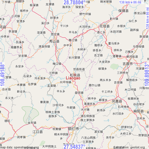
Liaogao GPS coordinates[2]
28° 10' 12" North, 109° 11' 42" East
| Map corner | latitude | longitude |
|---|---|---|
| Upper-left | 28.78804°, | 108.49188° |
| Center: | 28.17°, | 109.195° |
| Lower-right: | 27.54837°, | 109.89813° |
| Map W x H: | 137.8×137.8 km | = 85.6×85.6mi |
| max Lat: | 53.31946° ⇑72.7% North |
| Liaogao: | 28.17° |
| min Lat: | ⇓27.3% South 18.22056° |
| min Long | Liaogao | max Long |
| 75.07348° | 109.195° | 134.28917° |
| W 24.6%⇐ | ⇒75.4% E |
Elevation
Elevation of Liaogao is 384 m = 1260 ft, and this is 100.8 m = 331 ft below average elevation for this country.
| Max E: |
5622 m = 18445 ft | 31.6% |
| Avg. | 484.8 m = 1591 ft | |
| Liaogao | 384 m = 1260 ft | |
Min E: |
-3 m = -10 ft | 68.4% |
See also: China elevation on elevation.city.
Geographical zone
Liaogao is located in North temperate zone (between Tropic of Cancer and the Arctic Circle). Distance of this Northern Tropic circle is 526.3 km =327 mi to South.| Distance of | km | miles | from Liaogao |
|---|---|---|---|
| North Pole | 6874.9 | 4271.9 | to North |
| Arctic Circle | 4269 | 2652.6 | to North |
| Tropic Cancer | 526.3 | 327 | to South |
| Equator | 3132.2 | 1946.3 | to South |


Nearby cities:
15 places around Liaogao: (largest is in red/bold)
• Bajia
13.8 km =8.6 mi,  292°
292°
• Changping
11.2 km =7 mi,  135°
135°
• Changxingbao
16.4 km =10.2 mi,  359°
359°
• Dapingchang
10.9 km =6.8 mi,  232°
232°
• Huangban
9.9 km =6.2 mi,  339°
339°
• Jiujiang
6.6 km =4.1 mi,  267°
267°
• Lanqiao
19.9 km =12.4 mi,  275°
275°
• Lianglin
18.6 km =11.6 mi,  94°
94°
• Meijiang
19.5 km =12.1 mi,  302°
302°
• Miao’ai
17 km =10.6 mi, 271°
• Panshi
11.3 km =7 mi,  59°
59°
• Panxin
16.9 km =10.5 mi,  166°
166°
• Pingtou
19.5 km =12.1 mi,  219°
219°
• Taipingying
8.6 km =5.3 mi,  201°
201°
• Yaxi
18 km =11.2 mi,  78°
78°
Sources, notices
• [Note1] Compared only with cities in China existing in our database
• [Src1] Map data: © OpenStreetMap contributors (CC-BY-SA)
• [Src2] Other city data from geonames.org with taken over terms of usage.
• [Src3] Geographical zone / Annual Mean Temperature by Robert A. Rohde @ Wikipedia
