Taipingying geodata
Taipingying (Guizhou) is a seat of a fourth-order administrative division; located in China in Asia/Shanghai (GMT+8) time zone. In our database, there are 1268 cities with bigger population. Compared to other cities in China, 73.3% of cities are located further ↑North; 75.6% of cities are located further →East and 69.3% of cities have lower elevation than Taipingying. Note1


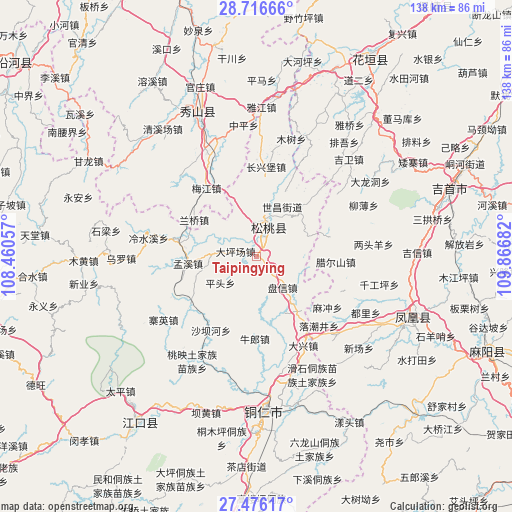
Taipingying GPS coordinates[2]
28° 5' 53.556" North, 109° 9' 49.284" East
| Map corner | latitude | longitude |
|---|---|---|
| Upper-left | 28.71666°, | 108.46057° |
| Center: | 28.09821°, | 109.16369° |
| Lower-right: | 27.47617°, | 109.86682° |
| Map W x H: | 137.9×137.9 km | = 85.7×85.7mi |
| max Lat: | 53.31946° ⇑73.3% North |
| Taipingying: | 28.09821° |
| min Lat: | ⇓26.7% South 18.22056° |
| min Long | Taipingying | max Long |
| 75.07348° | 109.16369° | 134.28917° |
| W 24.4%⇐ | ⇒75.6% E |
Elevation
Elevation of Taipingying is 397 m = 1302 ft, and this is 87.8 m = 288 ft below average elevation for this country.
| Max E: |
5622 m = 18445 ft | 30.7% |
| Avg. | 484.8 m = 1591 ft | |
| Taipingying | 397 m = 1302 ft | |
Min E: |
-3 m = -10 ft | 69.3% |
See also: China elevation on elevation.city.
Geographical zone
Taipingying is located in North temperate zone (between Tropic of Cancer and the Arctic Circle). Distance of this Northern Tropic circle is 518.3 km =322.1 mi to South.| Distance of | km | miles | from Taipingying |
|---|---|---|---|
| North Pole | 6882.8 | 4276.8 | to North |
| Arctic Circle | 4276.9 | 2657.5 | to North |
| Tropic Cancer | 518.3 | 322.1 | to South |
| Equator | 3124.2 | 1941.3 | to South |


Nearby cities:
15 places around Taipingying: (largest is in red/bold)
• Bajia
16.4 km =10.2 mi,  323°
323°
• Changping
11 km =6.8 mi,  89°
89°
• Dalu
21.1 km =13.1 mi,  283°
283°
• Dapingchang
5.7 km =3.5 mi, 283°
• Huangban
17.3 km =10.7 mi,  358°
358°
• Jiujiang
8.5 km =5.3 mi,  335°
335°
• Lanqiao
19.5 km =12.1 mi,  300°
300°
• La’ershan
21.5 km =13.4 mi, 94°
• Lianglin
22.6 km =14 mi,  72°
72°
• Liaogao
8.6 km =5.3 mi,  21°
21°
• Mengxi
18.5 km =11.5 mi,  263°
263°
• Miao’ai
16.3 km =10.1 mi, 301°
• Panshi
18.8 km =11.7 mi,  43°
43°
• Panxin
11 km =6.8 mi,  139°
139°
• Pingtou
11.7 km =7.3 mi,  233°
233°
Sources, notices
• [Note1] Compared only with cities in China existing in our database
• [Src1] Map data: © OpenStreetMap contributors (CC-BY-SA)
• [Src2] Other city data from geonames.org with taken over terms of usage.
• [Src3] Geographical zone / Annual Mean Temperature by Robert A. Rohde @ Wikipedia
