Liangguang geodata
Liangguang (Guangdong) is a seat of a fourth-order administrative division; located in China in Asia/Urumqi (GMT+6) time zone. In our database, there are 1268 cities with bigger population. Compared to other cities in China, 98% of cities are located further ↑North; 68.9% of cities are located further →East and 75.7% of cities have higher elevation than Liangguang. Note1


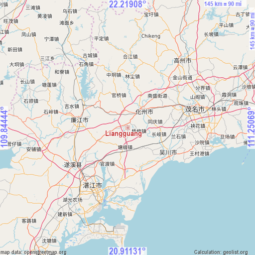
Liangguang GPS coordinates[2]
21° 34' 0.012" North, 110° 32' 51.216" East
| Map corner | latitude | longitude |
|---|---|---|
| Upper-left | 22.21908°, | 109.84444° |
| Center: | 21.56667°, | 110.54756° |
| Lower-right: | 20.91131°, | 111.25069° |
| Map W x H: | 145.4×145.4 km | = 90.3×90.3mi |
| max Lat: | 53.31946° ⇑98% North |
| Liangguang: | 21.56667° |
| min Lat: | ⇓2% South 18.22056° |
| min Long | Liangguang | max Long |
| 75.07348° | 110.54756° | 134.28917° |
| W 31.1%⇐ | ⇒68.9% E |
Elevation
Elevation of Liangguang is 35 m = 115 ft, and this is 449.8 m = 1476 ft below average elevation for this country.
| Max E: |
5622 m = 18445 ft | 75.7% |
| Avg. | 484.8 m = 1591 ft | |
| Liangguang | 35 m = 115 ft | |
Min E: |
-3 m = -10 ft | 24.3% |
See also: China elevation on elevation.city.
Geographical zone
Liangguang is located in North Torrid zone (between Equator and Tropic of Cancer). Distance of this Northern Tropic circle is 207.9 km =129.2 mi to North.| Distance of | km | miles | from Liangguang |
|---|---|---|---|
| North Pole | 7609.1 | 4728.1 | to North |
| Arctic Circle | 5003.2 | 3108.8 | to North |
| Tropic Cancer | 207.9 | 129.2 | to North |
| Equator | 2398 | 1490 | to South |


Nearby cities:
15 places around Liangguang: (largest is in red/bold)
• Changqi
18.5 km =11.5 mi,  101°
101°
• Daqiao
5.2 km =3.2 mi,  278°
278°
• Dongshan
15 km =9.3 mi,  42°
42°
• Guanqiao
19.4 km =12.1 mi,  343°
343°
• Hexi
12.1 km =7.5 mi, 38°
• Hexi
16.1 km =10 mi,  33°
33°
• Huazhou
8.3 km =5.2 mi, 26°
• Liangdong
17.3 km =10.7 mi,  244°
244°
• Shiwan
11.3 km =7 mi,  354°
354°
• Tangtuzhui
10.3 km =6.4 mi,  185°
185°
• Tongqing
15.2 km =9.4 mi,  79°
79°
• Xiaguo
11.9 km =7.4 mi,  47°
47°
• Xin’an
15.2 km =9.4 mi,  307°
307°
• Yangmei
6.9 km =4.3 mi,  111°
111°
• Zhangpu
19.9 km =12.4 mi,  129°
129°
Sources, notices
• [Note1] Compared only with cities in China existing in our database
• [Src1] Map data: © OpenStreetMap contributors (CC-BY-SA)
• [Src2] Other city data from geonames.org with taken over terms of usage.
• [Src3] Geographical zone / Annual Mean Temperature by Robert A. Rohde @ Wikipedia
