Huazhou geodata
Huazhou (Guangdong) is a populated place; located in China in Asia/Urumqi (GMT+6) time zone. With population of 91,701 people, there are 460 cities with bigger population in this country. Compared to other cities in China, 97.9% of cities are located further ↑North; 68.7% of cities are located further →East and 75.7% of cities have higher elevation than Huazhou. Note1


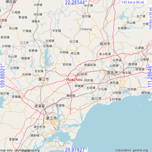
Huazhou GPS coordinates[2]
21° 37' 59.988" North, 110° 34' 59.988" East
| Map corner | latitude | longitude |
|---|---|---|
| Upper-left | 22.28544°, | 109.88021° |
| Center: | 21.63333°, | 110.58333° |
| Lower-right: | 20.97827°, | 111.28646° |
| Map W x H: | 145.3×145.3 km | = 90.3×90.3mi |
| max Lat: | 53.31946° ⇑97.9% North |
| Huazhou: | 21.63333° |
| min Lat: | ⇓2.1% South 18.22056° |
| min Long | Huazhou | max Long |
| 75.07348° | 110.58333° | 134.28917° |
| W 31.3%⇐ | ⇒68.7% E |
Elevation
Elevation of Huazhou is 35 m = 115 ft, and this is 449.8 m = 1476 ft below average elevation for this country.
| Max E: |
5622 m = 18445 ft | 75.7% |
| Avg. | 484.8 m = 1591 ft | |
| Huazhou | 35 m = 115 ft | |
Min E: |
-3 m = -10 ft | 24.3% |
See also: Huazhou elevation on elevation.city.
Geographical zone
Huazhou is located in North Torrid zone (between Equator and Tropic of Cancer). Distance of this Northern Tropic circle is 200.5 km =124.6 mi to North.| Distance of | km | miles | from Huazhou |
|---|---|---|---|
| North Pole | 7601.7 | 4723.5 | to North |
| Arctic Circle | 4995.8 | 3104.2 | to North |
| Tropic Cancer | 200.5 | 124.6 | to North |
| Equator | 2405.4 | 1494.6 | to South |


Nearby cities:
15 places around Huazhou: (largest is in red/bold)
• Changqi
18.2 km =11.3 mi,  127°
127°
• Daqiao
11.1 km =6.9 mi,  233°
233°
• Dongshan
7.4 km =4.6 mi,  59°
59°
• Guanqiao
14.5 km =9 mi,  321°
321°
• Hexi
4.4 km =2.7 mi, 62°
• Hexi
7.9 km =4.9 mi,  41°
41°
• Liangguang
8.3 km =5.2 mi,  206°
206°
• Ligang
13.6 km =8.5 mi,  16°
16°
• Nansheng
17 km =10.6 mi,  49°
49°
• Qianshui
18.3 km =11.4 mi,  106°
106°
• Shiwan
6.2 km =3.9 mi,  308°
308°
• Tongqing
12.2 km =7.6 mi, 111°
• Xiaguo
5.1 km =3.2 mi,  82°
82°
• Xin’an
15.8 km =9.8 mi,  276°
276°
• Yangmei
10.3 km =6.4 mi,  164°
164°
Sources, notices
• [Note1] Compared only with cities in China existing in our database
• [Src1] Map data: © OpenStreetMap contributors (CC-BY-SA)
• [Src2] Other city data from geonames.org with taken over terms of usage.
• [Src3] Geographical zone / Annual Mean Temperature by Robert A. Rohde @ Wikipedia
