Leping geodata
Leping (Jiangxi) is a seat of a third-order administrative division; located in China in Asia/Shanghai (GMT+8) time zone. In our database, there are 1268 cities with bigger population. Compared to other cities in China, 65.8% of cities are located further ↑North; 66.5% of cities are located further ←West and 81.6% of cities have higher elevation than Leping. Note1


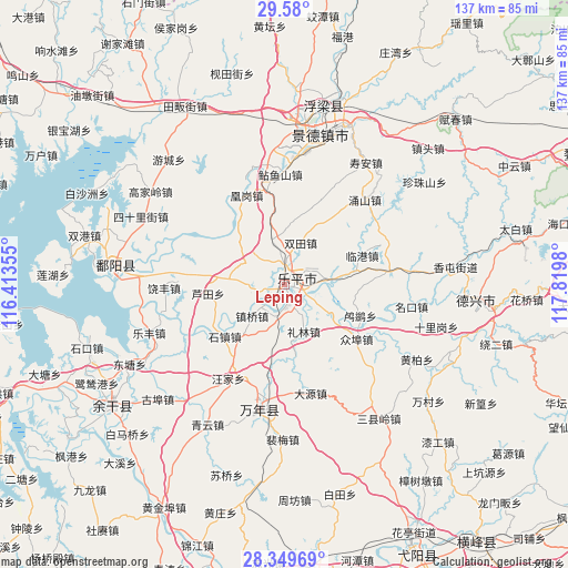
Leping GPS coordinates[2]
28° 58' 0.012" North, 117° 7' 0.012" East
| Map corner | latitude | longitude |
|---|---|---|
| Upper-left | 29.58°, | 116.41355° |
| Center: | 28.96667°, | 117.11667° |
| Lower-right: | 28.34969°, | 117.8198° |
| Map W x H: | 136.8×136.8 km | = 85×85mi |
| max Lat: | 53.31946° ⇑65.8% North |
| Leping: | 28.96667° |
| min Lat: | ⇓34.2% South 18.22056° |
| min Long | Leping | max Long |
| 75.07348° | 117.11667° | 134.28917° |
| W 66.5%⇐ | ⇒33.5% E |
Elevation
Elevation of Leping is 23 m = 75 ft, and this is 461.8 m = 1515 ft below average elevation for this country.
| Max E: |
5622 m = 18445 ft | 81.6% |
| Avg. | 484.8 m = 1591 ft | |
| Leping | 23 m = 75 ft | |
Min E: |
-3 m = -10 ft | 18.4% |
See also: China elevation on elevation.city.
Geographical zone
Leping is located in North temperate zone (between Tropic of Cancer and the Arctic Circle). Distance of this Northern Tropic circle is 614.9 km =382.1 mi to South.| Distance of | km | miles | from Leping |
|---|---|---|---|
| North Pole | 6786.3 | 4216.8 | to North |
| Arctic Circle | 4180.4 | 2597.6 | to North |
| Tropic Cancer | 614.9 | 382.1 | to South |
| Equator | 3220.8 | 2001.3 | to South |


Nearby cities:
15 places around Leping: (largest is in red/bold)
• Dongxi
21.3 km =13.2 mi,  331°
331°
• Hetang
23.5 km =14.6 mi,  5°
5°
• Jiedu
5.2 km =3.2 mi,  110°
110°
• Lilin
12.4 km =7.7 mi,  157°
157°
• Lingang
19.9 km =12.4 mi,  69°
69°
• Lusi
19.7 km =12.2 mi, 112°
• Lutianxiang
18.7 km =11.6 mi,  263°
263°
• Raobu
19.2 km =11.9 mi,  239°
239°
• Shizhen
19.3 km =12 mi,  229°
229°
• Shuangtian
10.7 km =6.6 mi,  20°
20°
• Taqian
11.2 km =7 mi,  342°
342°
• Wukou
12 km =7.5 mi,  82°
82°
• Zhenqiao
11 km =6.8 mi, 226°
• Zhongbu
22 km =13.7 mi,  127°
127°
• Zhutian
23.4 km =14.5 mi,  188°
188°
Sources, notices
• [Note1] Compared only with cities in China existing in our database
• [Src1] Map data: © OpenStreetMap contributors (CC-BY-SA)
• [Src2] Other city data from geonames.org with taken over terms of usage.
• [Src3] Geographical zone / Annual Mean Temperature by Robert A. Rohde @ Wikipedia
