Jiuzhen geodata
Jiuzhen (Hubei) is a seat of a fourth-order administrative division; located in China in Asia/Shanghai (GMT+8) time zone. In our database, there are 1268 cities with bigger population. Compared to other cities in China, 52.5% of cities are located further ↓South; 56.2% of cities are located further →East and 73.7% of cities have higher elevation than Jiuzhen. Note1


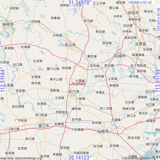
Jiuzhen GPS coordinates[2]
30° 44' 50.64" North, 113° 12' 53.136" East
| Map corner | latitude | longitude |
|---|---|---|
| Upper-left | 31.34978°, | 112.51164° |
| Center: | 30.7474°, | 113.21476° |
| Lower-right: | 30.14123°, | 113.91789° |
| Map W x H: | 134.4×134.4 km | = 83.5×83.5mi |
| max Lat: | 53.31946° ⇑47.5% North |
| Jiuzhen: | 30.7474° |
| min Lat: | ⇓52.5% South 18.22056° |
| min Long | Jiuzhen | max Long |
| 75.07348° | 113.21476° | 134.28917° |
| W 43.8%⇐ | ⇒56.2% E |
Elevation
Elevation of Jiuzhen is 40 m = 131 ft, and this is 444.8 m = 1459 ft below average elevation for this country.
| Max E: |
5622 m = 18445 ft | 73.7% |
| Avg. | 484.8 m = 1591 ft | |
| Jiuzhen | 40 m = 131 ft | |
Min E: |
-3 m = -10 ft | 26.3% |
See also: China elevation on elevation.city.
Geographical zone
Jiuzhen is located in North temperate zone (between Tropic of Cancer and the Arctic Circle). Distance of this Northern Tropic circle is 812.9 km =505.1 mi to South.| Distance of | km | miles | from Jiuzhen |
|---|---|---|---|
| North Pole | 6588.3 | 4093.8 | to North |
| Arctic Circle | 3982.4 | 2474.5 | to North |
| Tropic Cancer | 812.9 | 505.1 | to South |
| Equator | 3418.8 | 2124.3 | to South |


Nearby cities:
15 places around Jiuzhen: (largest is in red/bold)
• Houkou
15.4 km =9.6 mi,  207°
207°
• Huangtan
15.7 km =9.8 mi,  232°
232°
• Hushi
16.6 km =10.3 mi,  78°
78°
• Jingling
12.3 km =7.6 mi, 205°
• Jingling
15.4 km =9.6 mi, 225°
• Jingtan
19.7 km =12.2 mi,  121°
121°
• Liuhe
19.2 km =11.9 mi,  63°
63°
• Lushi
14.7 km =9.1 mi,  127°
127°
• Qianchang
15.5 km =9.6 mi,  311°
311°
• Shihe
12.9 km =8 mi,  275°
275°
• Sihe
10 km =6.2 mi,  103°
103°
• Tianmen
11.4 km =7.1 mi, 210°
• Xiaoban
15.1 km =9.4 mi,  178°
178°
• Yanglin
12.1 km =7.5 mi,  192°
192°
• Zaoshi
16.6 km =10.3 mi,  43°
43°
Sources, notices
• [Note1] Compared only with cities in China existing in our database
• [Src1] Map data: © OpenStreetMap contributors (CC-BY-SA)
• [Src2] Other city data from geonames.org with taken over terms of usage.
• [Src3] Geographical zone / Annual Mean Temperature by Robert A. Rohde @ Wikipedia
