Huangtan geodata
Huangtan (Hubei) is a seat of a fourth-order administrative division; located in China in Asia/Shanghai (GMT+8) time zone. In our database, there are 1268 cities with bigger population. Compared to other cities in China, 51.7% of cities are located further ↓South; 57% of cities are located further →East and 77.7% of cities have higher elevation than Huangtan. Note1


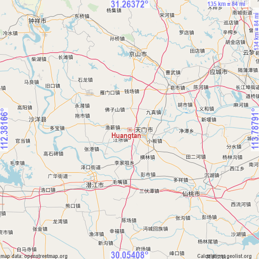
Huangtan GPS coordinates[2]
30° 39' 38.844" North, 113° 5' 5.208" East
| Map corner | latitude | longitude |
|---|---|---|
| Upper-left | 31.26372°, | 112.38166° |
| Center: | 30.66079°, | 113.08478° |
| Lower-right: | 30.05408°, | 113.78791° |
| Map W x H: | 134.5×134.5 km | = 83.6×83.6mi |
| max Lat: | 53.31946° ⇑48.3% North |
| Huangtan: | 30.66079° |
| min Lat: | ⇓51.7% South 18.22056° |
| min Long | Huangtan | max Long |
| 75.07348° | 113.08478° | 134.28917° |
| W 43%⇐ | ⇒57% E |
Elevation
Elevation of Huangtan is 31 m = 102 ft, and this is 453.8 m = 1489 ft below average elevation for this country.
| Max E: |
5622 m = 18445 ft | 77.7% |
| Avg. | 484.8 m = 1591 ft | |
| Huangtan | 31 m = 102 ft | |
Min E: |
-3 m = -10 ft | 22.3% |
See also: China elevation on elevation.city.
Geographical zone
Huangtan is located in North temperate zone (between Tropic of Cancer and the Arctic Circle). Distance of this Northern Tropic circle is 803.2 km =499.1 mi to South.| Distance of | km | miles | from Huangtan |
|---|---|---|---|
| North Pole | 6597.9 | 4099.7 | to North |
| Arctic Circle | 3992 | 2480.5 | to North |
| Tropic Cancer | 803.2 | 499.1 | to South |
| Equator | 3409.2 | 2118.4 | to South |


Nearby cities:
15 places around Huangtan: (largest is in red/bold)
• Fozishan
13.2 km =8.2 mi,  322°
322°
• Henglin
16.8 km =10.4 mi,  147°
147°
• Houkou
6.6 km =4.1 mi,  127°
127°
• Jiangchang
15.6 km =9.7 mi,  248°
248°
• Jingling
1.9 km =1.2 mi, 129°
• Jingling
7.3 km =4.5 mi,  101°
101°
• Jiuzhen
15.7 km =9.8 mi,  52°
52°
• Lijiazui
17.2 km =10.7 mi,  189°
189°
• Shihe
10.8 km =6.7 mi,  357°
357°
• Tianmen
6.6 km =4.1 mi,  91°
91°
• Wangchang
7 km =4.3 mi,  224°
224°
• Xiaoban
13.8 km =8.6 mi,  113°
113°
• Yanglin
10.1 km =6.3 mi, 102°
• Yuxin
9.1 km =5.7 mi,  278°
278°
• Zhengchang
19.5 km =12.1 mi,  196°
196°
Sources, notices
• [Note1] Compared only with cities in China existing in our database
• [Src1] Map data: © OpenStreetMap contributors (CC-BY-SA)
• [Src2] Other city data from geonames.org with taken over terms of usage.
• [Src3] Geographical zone / Annual Mean Temperature by Robert A. Rohde @ Wikipedia
