Jintang geodata
Jintang (Guangdong) is a seat of a fourth-order administrative division; located in China in Asia/Urumqi (GMT+6) time zone. In our database, there are 1268 cities with bigger population. Compared to other cities in China, 97.6% of cities are located further ↑North; 67.7% of cities are located further →East and 82.4% of cities have higher elevation than Jintang. Note1


Jintang GPS coordinates[2]
21° 45' 6.228" North, 110° 50' 32.64" East
| Map corner | latitude | longitude |
|---|---|---|
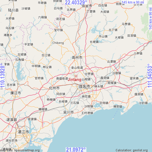
| Upper-left | 22.40329°, | 110.13928° |
| Center: | 21.75173°, | 110.8424° |
| Lower-right: | 21.0972°, | 111.54553° |
| Map W x H: | 145.2×145.2 km | = 90.2×90.2mi |
| max Lat: | 53.31946° ⇑97.6% North |
| Jintang: | 21.75173° |
| min Lat: | ⇓2.4% South 18.22056° |
| min Long | Jintang | max Long |
| 75.07348° | 110.8424° | 134.28917° |
| W 32.3%⇐ | ⇒67.7% E |
Elevation
Elevation of Jintang is 21 m = 69 ft, and this is 463.8 m = 1522 ft below average elevation for this country.
| Max E: |
5622 m = 18445 ft | 82.4% |
| Avg. | 484.8 m = 1591 ft | |
| Jintang | 21 m = 69 ft | |
Min E: |
-3 m = -10 ft | 17.6% |
See also: China elevation on elevation.city.
Geographical zone
Jintang is located in North Torrid zone (between Equator and Tropic of Cancer). Distance of this Northern Tropic circle is 187.4 km =116.4 mi to North.| Distance of | km | miles | from Jintang |
|---|---|---|---|
| North Pole | 7588.5 | 4715.3 | to North |
| Arctic Circle | 4982.6 | 3096 | to North |
| Tropic Cancer | 187.4 | 116.4 | to North |
| Equator | 2418.6 | 1502.8 | to South |


Nearby cities:
15 places around Jintang: (largest is in red/bold)
• Fenjie
12.7 km =7.9 mi,  79°
79°
• Gaoshan
12.3 km =7.6 mi,  151°
151°
• Gongguan
7.6 km =4.7 mi,  183°
183°
• Guandu
11.3 km =7 mi,  135°
135°
• Hedong
12.9 km =8 mi, 136°
• Hexi
9.8 km =6.1 mi, 142°
• Jinshan
9.3 km =5.8 mi,  356°
356°
• Maoming
12.8 km =8 mi, 152°
• Nansheng
14 km =8.7 mi,  261°
261°
• Shange
9.3 km =5.8 mi,  106°
106°
• Shigu
11.4 km =7.1 mi,  315°
315°
• Shiziling
15.4 km =9.6 mi,  352°
352°
• Xinpo
11.3 km =7 mi, 152°
• Yangjiao
16.8 km =10.4 mi,  119°
119°
• Zhencheng
15.8 km =9.8 mi, 177°
Sources, notices
• [Note1] Compared only with cities in China existing in our database
• [Src1] Map data: © OpenStreetMap contributors (CC-BY-SA)
• [Src2] Other city data from geonames.org with taken over terms of usage.
• [Src3] Geographical zone / Annual Mean Temperature by Robert A. Rohde @ Wikipedia
