Zhencheng geodata
Zhencheng (Guangdong) is a seat of a fourth-order administrative division; located in China in Asia/Urumqi (GMT+6) time zone. In our database, there are 1268 cities with bigger population. Compared to other cities in China, 97.9% of cities are located further ↑North; 67.7% of cities are located further →East and 82.9% of cities have higher elevation than Zhencheng. Note1


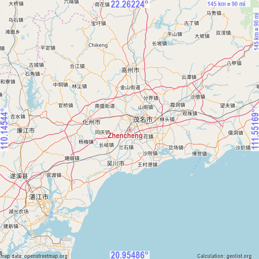
Zhencheng GPS coordinates[2]
21° 36' 36.108" North, 110° 50' 54.816" East
| Map corner | latitude | longitude |
|---|---|---|
| Upper-left | 22.26224°, | 110.14544° |
| Center: | 21.61003°, | 110.84856° |
| Lower-right: | 20.95486°, | 111.55169° |
| Map W x H: | 145.4×145.4 km | = 90.3×90.3mi |
| max Lat: | 53.31946° ⇑97.9% North |
| Zhencheng: | 21.61003° |
| min Lat: | ⇓2.1% South 18.22056° |
| min Long | Zhencheng | max Long |
| 75.07348° | 110.84856° | 134.28917° |
| W 32.3%⇐ | ⇒67.7% E |
Elevation
Elevation of Zhencheng is 20 m = 66 ft, and this is 464.8 m = 1525 ft below average elevation for this country.
| Max E: |
5622 m = 18445 ft | 82.9% |
| Avg. | 484.8 m = 1591 ft | |
| Zhencheng | 20 m = 66 ft | |
Min E: |
-3 m = -10 ft | 17.1% |
See also: China elevation on elevation.city.
Geographical zone
Zhencheng is located in North Torrid zone (between Equator and Tropic of Cancer). Distance of this Northern Tropic circle is 203.1 km =126.2 mi to North.| Distance of | km | miles | from Zhencheng |
|---|---|---|---|
| North Pole | 7604.3 | 4725.1 | to North |
| Arctic Circle | 4998.4 | 3105.9 | to North |
| Tropic Cancer | 203.1 | 126.2 | to North |
| Equator | 2402.8 | 1493 | to South |


Nearby cities:
15 places around Zhencheng: (largest is in red/bold)
• Aotou
6.4 km =4 mi,  171°
171°
• Changqi
15.5 km =9.6 mi,  236°
236°
• Gaoshan
7.1 km =4.4 mi,  46°
46°
• Gongguan
8.2 km =5.1 mi,  351°
351°
• Guandu
10.6 km =6.6 mi,  43°
43°
• Hedong
10.4 km =6.5 mi, 52°
• Hexi
9.6 km =6 mi,  33°
33°
• Lanshi
10.7 km =6.6 mi,  192°
192°
• Maoming
6.9 km =4.3 mi, 50°
• Meihua
9.6 km =6 mi,  111°
111°
• Qianshui
10.3 km =6.4 mi,  254°
254°
• Qijing
15.7 km =9.8 mi, 107°
• Shange
15.6 km =9.7 mi, 32°
• Xiaoliang
13.7 km =8.5 mi,  161°
161°
• Xinpo
7.4 km =4.6 mi, 38°
Sources, notices
• [Note1] Compared only with cities in China existing in our database
• [Src1] Map data: © OpenStreetMap contributors (CC-BY-SA)
• [Src2] Other city data from geonames.org with taken over terms of usage.
• [Src3] Geographical zone / Annual Mean Temperature by Robert A. Rohde @ Wikipedia
