Jinshi geodata
Jinshi (Hunan) is a seat of a third-order administrative division; located in China in Asia/Shanghai (GMT+8) time zone. With population of 82,906 people, there are 512 cities with bigger population in this country. Compared to other cities in China, 58.5% of cities are located further ↑North; 63.2% of cities are located further →East and 66.8% of cities have higher elevation than Jinshi. Note1


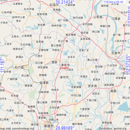
Jinshi GPS coordinates[2]
29° 36' 17.532" North, 111° 52' 12.432" East
| Map corner | latitude | longitude |
|---|---|---|
| Upper-left | 30.21434°, | 111.167° |
| Center: | 29.60487°, | 111.87012° |
| Lower-right: | 28.99169°, | 112.57325° |
| Map W x H: | 135.9×135.9 km | = 84.4×84.4mi |
| max Lat: | 53.31946° ⇑58.5% North |
| Jinshi: | 29.60487° |
| min Lat: | ⇓41.5% South 18.22056° |
| min Long | Jinshi | max Long |
| 75.07348° | 111.87012° | 134.28917° |
| W 36.8%⇐ | ⇒63.2% E |
Elevation
Elevation of Jinshi is 65 m = 213 ft, and this is 419.8 m = 1377 ft below average elevation for this country.
| Max E: |
5622 m = 18445 ft | 66.8% |
| Avg. | 484.8 m = 1591 ft | |
| Jinshi | 65 m = 213 ft | |
Min E: |
-3 m = -10 ft | 33.2% |
See also: Jinshi elevation on elevation.city.
Geographical zone
Jinshi is located in North temperate zone (between Tropic of Cancer and the Arctic Circle). Distance of this Northern Tropic circle is 685.8 km =426.1 mi to South.| Distance of | km | miles | from Jinshi |
|---|---|---|---|
| North Pole | 6715.3 | 4172.7 | to North |
| Arctic Circle | 4109.4 | 2553.5 | to North |
| Tropic Cancer | 685.8 | 426.1 | to South |
| Equator | 3291.8 | 2045.4 | to South |


Nearby cities:
15 places around Jinshi: (largest is in red/bold)
• Baiyi
16.5 km =10.3 mi,  178°
178°
• Cennan
18.9 km =11.7 mi,  328°
328°
• Daohe
15.2 km =9.4 mi,  244°
244°
• Guanyuan
14.5 km =9 mi,  110°
110°
• Jiuyuan
6.5 km =4 mi,  131°
131°
• Lidong
6.3 km =3.9 mi,  312°
312°
• Lijiapu
12.9 km =8 mi,  158°
158°
• Lingquan
9.7 km =6 mi,  207°
207°
• Liyang
12.6 km =7.8 mi,  294°
294°
• Li’nan
11.1 km =6.9 mi,  277°
277°
• Mengxi
16.9 km =10.5 mi,  342°
342°
• Rudong
18 km =11.2 mi,  37°
37°
• Xiaodukou
4.8 km =3 mi,  57°
57°
• Xinzhou
5.6 km =3.5 mi,  168°
168°
• Yongfeng
11 km =6.8 mi, 36°
Sources, notices
• [Note1] Compared only with cities in China existing in our database
• [Src1] Map data: © OpenStreetMap contributors (CC-BY-SA)
• [Src2] Other city data from geonames.org with taken over terms of usage.
• [Src3] Geographical zone / Annual Mean Temperature by Robert A. Rohde @ Wikipedia
