Daohe geodata
Daohe (Hunan) is a seat of a fourth-order administrative division; located in China in Asia/Shanghai (GMT+8) time zone. In our database, there are 1268 cities with bigger population. Compared to other cities in China, 59.2% of cities are located further ↑North; 63.9% of cities are located further →East and 74.8% of cities have higher elevation than Daohe. Note1


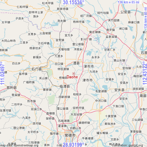
Daohe GPS coordinates[2]
29° 32' 43.908" North, 111° 43' 41.124" East
| Map corner | latitude | longitude |
|---|---|---|
| Upper-left | 30.15536°, | 111.02497° |
| Center: | 29.54553°, | 111.72809° |
| Lower-right: | 28.93199°, | 112.43122° |
| Map W x H: | 136×136 km | = 84.5×84.5mi |
| max Lat: | 53.31946° ⇑59.2% North |
| Daohe: | 29.54553° |
| min Lat: | ⇓40.8% South 18.22056° |
| min Long | Daohe | max Long |
| 75.07348° | 111.72809° | 134.28917° |
| W 36.1%⇐ | ⇒63.9% E |
Elevation
Elevation of Daohe is 37 m = 121 ft, and this is 447.8 m = 1469 ft below average elevation for this country.
| Max E: |
5622 m = 18445 ft | 74.8% |
| Avg. | 484.8 m = 1591 ft | |
| Daohe | 37 m = 121 ft | |
Min E: |
-3 m = -10 ft | 25.2% |
See also: China elevation on elevation.city.
Geographical zone
Daohe is located in North temperate zone (between Tropic of Cancer and the Arctic Circle). Distance of this Northern Tropic circle is 679.2 km =422 mi to South.| Distance of | km | miles | from Daohe |
|---|---|---|---|
| North Pole | 6721.9 | 4176.8 | to North |
| Arctic Circle | 4116 | 2557.6 | to North |
| Tropic Cancer | 679.2 | 422 | to South |
| Equator | 3285.2 | 2041.3 | to South |


Nearby cities:
15 places around Daohe: (largest is in red/bold)
• Daping
15.2 km =9.4 mi,  327°
327°
• Fenghuo
9.8 km =6.1 mi,  168°
168°
• Hekou
17.1 km =10.6 mi,  302°
302°
• Jinshi
15.2 km =9.4 mi,  64°
64°
• Lidong
14.1 km =8.8 mi,  40°
40°
• Lingquan
9.4 km =5.8 mi,  101°
101°
• Linli
13 km =8.1 mi,  215°
215°
• Liyang
12 km =7.5 mi,  11°
11°
• Li’nan
8.4 km =5.2 mi,  18°
18°
• Tingxiandu
11 km =6.8 mi, 295°
• Wangcheng
16.3 km =10.1 mi,  207°
207°
• Xinzhou
14.9 km =9.3 mi,  85°
85°
• Xiumei
10.5 km =6.5 mi,  250°
250°
• Yangban
4 km =2.5 mi,  244°
244°
• Zhanggongmiao
10.1 km =6.3 mi,  308°
308°
Sources, notices
• [Note1] Compared only with cities in China existing in our database
• [Src1] Map data: © OpenStreetMap contributors (CC-BY-SA)
• [Src2] Other city data from geonames.org with taken over terms of usage.
• [Src3] Geographical zone / Annual Mean Temperature by Robert A. Rohde @ Wikipedia
