Jinhua geodata
Jinhua (Zhejiang) is a seat of a second-order administrative division; located in China in Asia/Shanghai (GMT+8) time zone. With population of 142,206 people, there are 312 cities with bigger population in this country. Compared to other cities in China, 64.3% of cities are located further ↑North; 79.7% of cities are located further ←West and 69.2% of cities have higher elevation than Jinhua. Note1


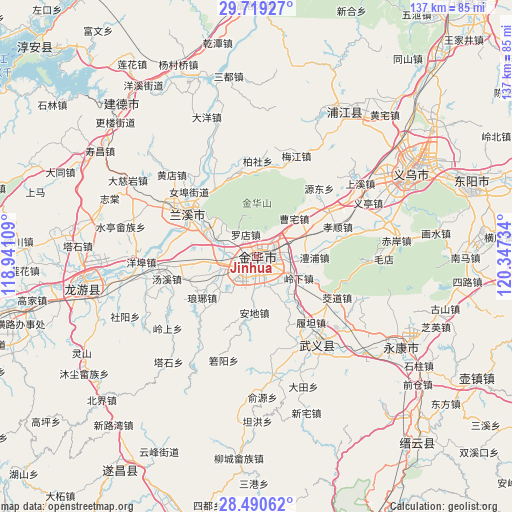
Jinhua GPS coordinates[2]
29° 6' 24.408" North, 119° 38' 39.156" East
| Map corner | latitude | longitude |
|---|---|---|
| Upper-left | 29.71927°, | 118.94109° |
| Center: | 29.10678°, | 119.64421° |
| Lower-right: | 28.49062°, | 120.34734° |
| Map W x H: | 136.6×136.6 km | = 84.9×84.9mi |
| max Lat: | 53.31946° ⇑64.3% North |
| Jinhua: | 29.10678° |
| min Lat: | ⇓35.7% South 18.22056° |
| min Long | Jinhua | max Long |
| 75.07348° | 119.64421° | 134.28917° |
| W 79.7%⇐ | ⇒20.3% E |
Elevation
Elevation of Jinhua is 55 m = 180 ft, and this is 429.8 m = 1410 ft below average elevation for this country.
| Max E: |
5622 m = 18445 ft | 69.2% |
| Avg. | 484.8 m = 1591 ft | |
| Jinhua | 55 m = 180 ft | |
Min E: |
-3 m = -10 ft | 30.8% |
See also: Jinhua elevation on elevation.city.
Geographical zone
Jinhua is located in North temperate zone (between Tropic of Cancer and the Arctic Circle). Distance of this Northern Tropic circle is 630.5 km =391.8 mi to South.| Distance of | km | miles | from Jinhua |
|---|---|---|---|
| North Pole | 6770.7 | 4207.1 | to North |
| Arctic Circle | 4164.8 | 2587.9 | to North |
| Tropic Cancer | 630.5 | 391.8 | to South |
| Equator | 3236.4 | 2011 | to South |


Nearby cities:
15 places around Jinhua: (largest is in red/bold)
• Bailongqiao
9.9 km =6.2 mi,  250°
250°
• Caozhai
15 km =9.3 mi,  43°
43°
• Changshan
13.4 km =8.3 mi,  224°
224°
• Chengzhong
0.4 km =0.2 mi,  95°
95°
• Chisong
8 km =5 mi, 36°
• Duohu
4.2 km =2.6 mi,  110°
110°
• Jiangdong
11.2 km =7 mi,  125°
125°
• Langya
18.2 km =11.3 mi,  232°
232°
• Lingxia
12.7 km =7.9 mi,  116°
116°
• Lipu
15.6 km =9.7 mi,  90°
90°
• Luodian
6.8 km =4.2 mi,  334°
334°
• Qiubin
4.8 km =3 mi, 220°
• Sumeng
8.5 km =5.3 mi,  184°
184°
• Xianqiao
6.9 km =4.3 mi,  45°
45°
• Yafan
8.4 km =5.2 mi,  158°
158°
Sources, notices
• [Note1] Compared only with cities in China existing in our database
• [Src1] Map data: © OpenStreetMap contributors (CC-BY-SA)
• [Src2] Other city data from geonames.org with taken over terms of usage.
• [Src3] Geographical zone / Annual Mean Temperature by Robert A. Rohde @ Wikipedia
