Lingxia geodata
Lingxia (Zhejiang) is a seat of a fourth-order administrative division; located in China in Asia/Shanghai (GMT+8) time zone. In our database, there are 1268 cities with bigger population. Compared to other cities in China, 64.8% of cities are located further ↑North; 80.3% of cities are located further ←West and 65.2% of cities have higher elevation than Lingxia. Note1


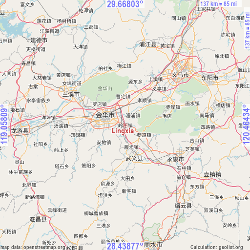
Lingxia GPS coordinates[2]
29° 3' 18.828" North, 119° 45' 40.356" East
| Map corner | latitude | longitude |
|---|---|---|
| Upper-left | 29.66803°, | 119.05809° |
| Center: | 29.05523°, | 119.76121° |
| Lower-right: | 28.43877°, | 120.46434° |
| Map W x H: | 136.7×136.7 km | = 84.9×84.9mi |
| max Lat: | 53.31946° ⇑64.8% North |
| Lingxia: | 29.05523° |
| min Lat: | ⇓35.2% South 18.22056° |
| min Long | Lingxia | max Long |
| 75.07348° | 119.76121° | 134.28917° |
| W 80.3%⇐ | ⇒19.7% E |
Elevation
Elevation of Lingxia is 72 m = 236 ft, and this is 412.8 m = 1354 ft below average elevation for this country.
| Max E: |
5622 m = 18445 ft | 65.2% |
| Avg. | 484.8 m = 1591 ft | |
| Lingxia | 72 m = 236 ft | |
Min E: |
-3 m = -10 ft | 34.8% |
See also: China elevation on elevation.city.
Geographical zone
Lingxia is located in North temperate zone (between Tropic of Cancer and the Arctic Circle). Distance of this Northern Tropic circle is 624.7 km =388.2 mi to South.| Distance of | km | miles | from Lingxia |
|---|---|---|---|
| North Pole | 6776.4 | 4210.7 | to North |
| Arctic Circle | 4170.5 | 2591.4 | to North |
| Tropic Cancer | 624.7 | 388.2 | to South |
| Equator | 3230.6 | 2007.4 | to South |


Nearby cities:
15 places around Lingxia: (largest is in red/bold)
• Bailongqiao
20.9 km =13 mi,  276°
276°
• Caozhai
16.6 km =10.3 mi,  356°
356°
• Changshan
21.1 km =13.1 mi,  259°
259°
• Chengzhong
12.3 km =7.6 mi,  297°
297°
• Chisong
13.8 km =8.6 mi,  331°
331°
• Duohu
8.5 km =5.3 mi, 300°
• Jiangdong
2.3 km =1.4 mi,  251°
251°
• Jinhua
12.7 km =7.9 mi, 296°
• Lipu
6.9 km =4.3 mi,  37°
37°
• Luodian
18.5 km =11.5 mi,  309°
309°
• Qiubin
14.6 km =9.1 mi, 277°
• Sumeng
12.3 km =7.6 mi, 257°
• Xianqiao
12.4 km =7.7 mi, 328°
• Xiaoshun
17.4 km =10.8 mi, 37°
• Yafan
8.6 km =5.3 mi, 256°
Sources, notices
• [Note1] Compared only with cities in China existing in our database
• [Src1] Map data: © OpenStreetMap contributors (CC-BY-SA)
• [Src2] Other city data from geonames.org with taken over terms of usage.
• [Src3] Geographical zone / Annual Mean Temperature by Robert A. Rohde @ Wikipedia
