Jianfeng geodata
Jianfeng (Hainan) is a seat of a fourth-order administrative division; located in China in Asia/Shanghai (GMT+8) time zone. In our database, there are 1268 cities with bigger population. Compared to other cities in China, 99.8% of cities are located further ↑North; 77.6% of cities are located further →East and 78.8% of cities have higher elevation than Jianfeng. Note1


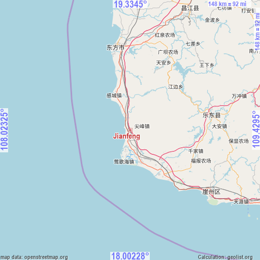
Jianfeng GPS coordinates[2]
18° 40' 10.92" North, 108° 43' 34.932" East
| Map corner | latitude | longitude |
|---|---|---|
| Upper-left | 19.3345°, | 108.02325° |
| Center: | 18.6697°, | 108.72637° |
| Lower-right: | 18.00228°, | 109.4295° |
| Map W x H: | 148.1×148.1 km | = 92×92mi |
| max Lat: | 53.31946° ⇑99.8% North |
| Jianfeng: | 18.6697° |
| min Lat: | ⇓0.2% South 18.22056° |
| min Long | Jianfeng | max Long |
| 75.07348° | 108.72637° | 134.28917° |
| W 22.4%⇐ | ⇒77.6% E |
Elevation
Elevation of Jianfeng is 29 m = 95 ft, and this is 455.8 m = 1495 ft below average elevation for this country.
| Max E: |
5622 m = 18445 ft | 78.8% |
| Avg. | 484.8 m = 1591 ft | |
| Jianfeng | 29 m = 95 ft | |
Min E: |
-3 m = -10 ft | 21.2% |
See also: China elevation on elevation.city.
Geographical zone
Jianfeng is located in North Torrid zone (between Equator and Tropic of Cancer). Distance of this Northern Tropic circle is 530 km =329.3 mi to North.| Distance of | km | miles | from Jianfeng |
|---|---|---|---|
| North Pole | 7931.2 | 4928.2 | to North |
| Arctic Circle | 5325.3 | 3309 | to North |
| Tropic Cancer | 530 | 329.3 | to North |
| Equator | 2075.9 | 1289.9 | to South |


Nearby cities:
15 places around Jianfeng: (largest is in red/bold)
• Banqiao
15.2 km =9.4 mi,  343°
343°
• Baoyou
47.7 km =29.6 mi,  79°
79°
• Basuo
47.8 km =29.7 mi,  350°
350°
• Da’an
51 km =31.7 mi,  86°
86°
• Donghe
47.9 km =29.8 mi,  27°
27°
• Foluo
9.9 km =6.2 mi,  178°
178°
• Gancheng
22.2 km =13.8 mi, 335°
• Huangliu
19.7 km =12.2 mi,  160°
160°
• Jiusuo
31.7 km =19.7 mi,  142°
142°
• Leluo
29.6 km =18.4 mi,  146°
146°
• Qianjia
39.1 km =24.3 mi,  106°
106°
• Tian’an
43.4 km =27 mi, 26°
• Yacheng
56.6 km =35.2 mi,  125°
125°
• Yinggehai
18 km =11.2 mi,  192°
192°
• Zhizhong
57.2 km =35.5 mi,  95°
95°
Sources, notices
• [Note1] Compared only with cities in China existing in our database
• [Src1] Map data: © OpenStreetMap contributors (CC-BY-SA)
• [Src2] Other city data from geonames.org with taken over terms of usage.
• [Src3] Geographical zone / Annual Mean Temperature by Robert A. Rohde @ Wikipedia
