Huilong geodata
Huilong (Fujian) is a seat of a fourth-order administrative division; located in China in Asia/Shanghai (GMT+8) time zone. In our database, there are 1268 cities with bigger population. Compared to other cities in China, 76.7% of cities are located further ↑North; 72.6% of cities are located further ←West and 51.9% of cities have lower elevation than Huilong. Note1


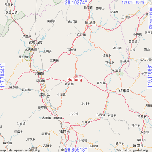
Huilong GPS coordinates[2]
27° 28' 50.628" North, 118° 24' 27.108" East
| Map corner | latitude | longitude |
|---|---|---|
| Upper-left | 28.10274°, | 117.70441° |
| Center: | 27.48073°, | 118.40753° |
| Lower-right: | 26.85518°, | 119.11066° |
| Map W x H: | 138.7×138.7 km | = 86.2×86.2mi |
| max Lat: | 53.31946° ⇑76.7% North |
| Huilong: | 27.48073° |
| min Lat: | ⇓23.3% South 18.22056° |
| min Long | Huilong | max Long |
| 75.07348° | 118.40753° | 134.28917° |
| W 72.6%⇐ | ⇒27.4% E |
Elevation
Elevation of Huilong is 180 m = 591 ft, and this is 304.8 m = 1000 ft below average elevation for this country.
| Max E: |
5622 m = 18445 ft | 48.1% |
| Avg. | 484.8 m = 1591 ft | |
| Huilong | 180 m = 591 ft | |
Min E: |
-3 m = -10 ft | 51.9% |
See also: China elevation on elevation.city.
Geographical zone
Huilong is located in North temperate zone (between Tropic of Cancer and the Arctic Circle). Distance of this Northern Tropic circle is 449.7 km =279.4 mi to South.| Distance of | km | miles | from Huilong |
|---|---|---|---|
| North Pole | 6951.5 | 4319.5 | to North |
| Arctic Circle | 4345.6 | 2700.2 | to North |
| Tropic Cancer | 449.7 | 279.4 | to South |
| Equator | 3055.6 | 1898.7 | to South |


Nearby cities:
15 places around Huilong: (largest is in red/bold)
• Dongping
23.5 km =14.6 mi,  104°
104°
• Haocun
13.7 km =8.5 mi,  25°
25°
• Huaqiao
33 km =20.5 mi,  67°
67°
• Longcun
26.7 km =16.6 mi,  161°
161°
• Shibei
24.6 km =15.3 mi,  349°
349°
• Shitun
36.7 km =22.8 mi,  111°
111°
• Shuibeijie
28.6 km =17.8 mi, 33°
• Shuiji
9 km =5.6 mi,  223°
223°
• Wufu
24.8 km =15.4 mi,  306°
306°
• Xiaohu
21.5 km =13.4 mi, 220°
• Xiaosong
34.6 km =21.5 mi,  183°
183°
• Xingtian
33.7 km =20.9 mi,  273°
273°
• Zhangdun
5.8 km =3.6 mi,  94°
94°
• Zhengdun
28.7 km =17.8 mi, 86°
• Zudun
33.6 km =20.9 mi,  55°
55°
Sources, notices
• [Note1] Compared only with cities in China existing in our database
• [Src1] Map data: © OpenStreetMap contributors (CC-BY-SA)
• [Src2] Other city data from geonames.org with taken over terms of usage.
• [Src3] Geographical zone / Annual Mean Temperature by Robert A. Rohde @ Wikipedia
