Xiaohu geodata
Xiaohu (Fujian) is a seat of a fourth-order administrative division; located in China in Asia/Shanghai (GMT+8) time zone. In our database, there are 1268 cities with bigger population. Compared to other cities in China, 77.3% of cities are located further ↑North; 71.8% of cities are located further ←West and 52.4% of cities have higher elevation than Xiaohu. Note1


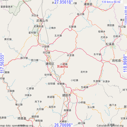
Xiaohu GPS coordinates[2]
27° 19' 59.988" North, 118° 16' 0.012" East
| Map corner | latitude | longitude |
|---|---|---|
| Upper-left | 27.95618°, | 117.56355° |
| Center: | 27.33333°, | 118.26667° |
| Lower-right: | 26.70696°, | 118.9698° |
| Map W x H: | 138.9×138.9 km | = 86.3×86.3mi |
| max Lat: | 53.31946° ⇑77.3% North |
| Xiaohu: | 27.33333° |
| min Lat: | ⇓22.7% South 18.22056° |
| min Long | Xiaohu | max Long |
| 75.07348° | 118.26667° | 134.28917° |
| W 71.8%⇐ | ⇒28.2% E |
Elevation
Elevation of Xiaohu is 147 m = 482 ft, and this is 337.8 m = 1108 ft below average elevation for this country.
| Max E: |
5622 m = 18445 ft | 52.4% |
| Avg. | 484.8 m = 1591 ft | |
| Xiaohu | 147 m = 482 ft | |
Min E: |
-3 m = -10 ft | 47.6% |
See also: China elevation on elevation.city.
Geographical zone
Xiaohu is located in North temperate zone (between Tropic of Cancer and the Arctic Circle). Distance of this Northern Tropic circle is 433.3 km =269.2 mi to South.| Distance of | km | miles | from Xiaohu |
|---|---|---|---|
| North Pole | 6967.9 | 4329.7 | to North |
| Arctic Circle | 4362 | 2710.4 | to North |
| Tropic Cancer | 433.3 | 269.2 | to South |
| Equator | 3039.2 | 1888.5 | to South |


Nearby cities:
15 places around Xiaohu: (largest is in red/bold)
• Dongfeng
34.2 km =21.3 mi,  138°
138°
• Dongping
38.2 km =23.7 mi,  73°
73°
• Haocun
34.9 km =21.7 mi,  34°
34°
• Huilong
21.5 km =13.4 mi,  40°
40°
• Jian’ou
32.4 km =20.1 mi,  169°
169°
• Jiyang
25.4 km =15.8 mi,  211°
211°
• Longcun
24.2 km =15 mi,  111°
111°
• Ouning
33.8 km =21 mi, 172°
• Shuiji
12.5 km =7.8 mi, 38°
• Wufu
31.6 km =19.6 mi,  348°
348°
• Xiaosong
21.6 km =13.4 mi,  146°
146°
• Xingtian
27.1 km =16.8 mi,  313°
313°
• Xushi
21.1 km =13.1 mi,  236°
236°
• Zhangdun
25.4 km =15.8 mi,  50°
50°
• Zhishan
32.7 km =20.3 mi, 169°
Sources, notices
• [Note1] Compared only with cities in China existing in our database
• [Src1] Map data: © OpenStreetMap contributors (CC-BY-SA)
• [Src2] Other city data from geonames.org with taken over terms of usage.
• [Src3] Geographical zone / Annual Mean Temperature by Robert A. Rohde @ Wikipedia
