Huangtang geodata
Huangtang (Guangdong) is a seat of a fourth-order administrative division; located in China in Asia/Shanghai (GMT+8) time zone. In our database, there are 1268 cities with bigger population. Compared to other cities in China, 91.4% of cities are located further ↑North; 54.3% of cities are located further ←West and 52.9% of cities have higher elevation than Huangtang. Note1


Huangtang GPS coordinates[2]
23° 41' 32.676" North, 114° 59' 28.752" East
| Map corner | latitude | longitude |
|---|---|---|
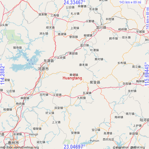
| Upper-left | 24.33467°, | 114.2882° |
| Center: | 23.69241°, | 114.99132° |
| Lower-right: | 23.04697°, | 115.69445° |
| Map W x H: | 143.2×143.2 km | = 89×89mi |
| max Lat: | 53.31946° ⇑91.4% North |
| Huangtang: | 23.69241° |
| min Lat: | ⇓8.6% South 18.22056° |
| min Long | Huangtang | max Long |
| 75.07348° | 114.99132° | 134.28917° |
| W 54.3%⇐ | ⇒45.7% E |
Elevation
Elevation of Huangtang is 144 m = 472 ft, and this is 340.8 m = 1118 ft below average elevation for this country.
| Max E: |
5622 m = 18445 ft | 52.9% |
| Avg. | 484.8 m = 1591 ft | |
| Huangtang | 144 m = 472 ft | |
Min E: |
-3 m = -10 ft | 47.1% |
See also: China elevation on elevation.city.
Geographical zone
Huangtang is located in North temperate zone (between Tropic of Cancer and the Arctic Circle). Distance of this Northern Tropic circle is 28.4 km =17.6 mi to South.| Distance of | km | miles | from Huangtang |
|---|---|---|---|
| North Pole | 7372.7 | 4581.2 | to North |
| Arctic Circle | 4766.8 | 2962 | to North |
| Tropic Cancer | 28.4 | 17.6 | to South |
| Equator | 2634.3 | 1636.9 | to South |


Nearby cities:
15 places around Huangtang: (largest is in red/bold)
• Baipu
14.4 km =8.9 mi,  277°
277°
• Fucheng
18.2 km =11.3 mi,  107°
107°
• Huangcun
28.7 km =17.8 mi,  56°
56°
• Huangtian
20.5 km =12.7 mi,  358°
358°
• Jiuhe
23 km =14.3 mi,  162°
162°
• Jiushe
10.2 km =6.3 mi,  341°
341°
• Kanghe
13.5 km =8.4 mi,  44°
44°
• Lakou
30.1 km =18.7 mi,  17°
17°
• Qingxi
17.6 km =10.9 mi,  192°
192°
• Waxi
21 km =13 mi,  145°
145°
• Wushi
21.9 km =13.6 mi, 109°
• Xiantang
27.1 km =16.8 mi,  302°
302°
• Yihe
20.3 km =12.6 mi,  323°
323°
• Yirong
24.9 km =15.5 mi,  220°
220°
• Zicheng
19.6 km =12.2 mi,  104°
104°
Sources, notices
• [Note1] Compared only with cities in China existing in our database
• [Src1] Map data: © OpenStreetMap contributors (CC-BY-SA)
• [Src2] Other city data from geonames.org with taken over terms of usage.
• [Src3] Geographical zone / Annual Mean Temperature by Robert A. Rohde @ Wikipedia
