Huangcun geodata
Huangcun (Guangdong) is a seat of a fourth-order administrative division; located in China in Asia/Shanghai (GMT+8) time zone. In our database, there are 1268 cities with bigger population. Compared to other cities in China, 90.9% of cities are located further ↑North; 55.5% of cities are located further ←West and 55.4% of cities have lower elevation than Huangcun. Note1


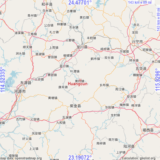
Huangcun GPS coordinates[2]
23° 50' 7.656" North, 115° 13' 35.292" East
| Map corner | latitude | longitude |
|---|---|---|
| Upper-left | 24.47701°, | 114.52335° |
| Center: | 23.83546°, | 115.22647° |
| Lower-right: | 23.19072°, | 115.9296° |
| Map W x H: | 143×143 km | = 88.9×88.9mi |
| max Lat: | 53.31946° ⇑90.9% North |
| Huangcun: | 23.83546° |
| min Lat: | ⇓9.1% South 18.22056° |
| min Long | Huangcun | max Long |
| 75.07348° | 115.22647° | 134.28917° |
| W 55.5%⇐ | ⇒44.5% E |
Elevation
Elevation of Huangcun is 210 m = 689 ft, and this is 274.8 m = 902 ft below average elevation for this country.
| Max E: |
5622 m = 18445 ft | 44.6% |
| Avg. | 484.8 m = 1591 ft | |
| Huangcun | 210 m = 689 ft | |
Min E: |
-3 m = -10 ft | 55.4% |
See also: China elevation on elevation.city.
Geographical zone
Huangcun is located in North temperate zone (between Tropic of Cancer and the Arctic Circle). Distance of this Northern Tropic circle is 44.3 km =27.5 mi to South.| Distance of | km | miles | from Huangcun |
|---|---|---|---|
| North Pole | 7356.8 | 4571.3 | to North |
| Arctic Circle | 4750.9 | 2952.1 | to North |
| Tropic Cancer | 44.3 | 27.5 | to South |
| Equator | 2650.3 | 1646.8 | to South |


Nearby cities:
15 places around Huangcun: (largest is in red/bold)
• Changbu
22 km =13.7 mi,  102°
102°
• Datian
22.5 km =14 mi,  83°
83°
• Fucheng
22.3 km =13.9 mi,  196°
196°
• Heshi
23.5 km =14.6 mi,  34°
34°
• Huangbu
17.7 km =11 mi,  24°
24°
• Huangtian
24.8 km =15.4 mi,  280°
280°
• Kanghe
15.7 km =9.8 mi,  246°
246°
• Lakou
19.6 km =12.2 mi,  310°
310°
• Lankou
19.2 km =11.9 mi, 311°
• Liucheng
24.7 km =15.3 mi,  333°
333°
• Wushi
23.5 km =14.6 mi,  187°
187°
• Yetan
9.4 km =5.8 mi, 329°
• Zhongba
18.6 km =11.6 mi,  138°
138°
• Zicheng
21.5 km =13.4 mi, 193°
• Zishi
16.6 km =10.3 mi,  49°
49°
Sources, notices
• [Note1] Compared only with cities in China existing in our database
• [Src1] Map data: © OpenStreetMap contributors (CC-BY-SA)
• [Src2] Other city data from geonames.org with taken over terms of usage.
• [Src3] Geographical zone / Annual Mean Temperature by Robert A. Rohde @ Wikipedia
