Huangmu geodata
Huangmu (Anhui) is a seat of a fourth-order administrative division; located in China in Asia/Shanghai (GMT+8) time zone. In our database, there are 1268 cities with bigger population. Compared to other cities in China, 55.4% of cities are located further ↓South; 72.3% of cities are located further ←West and 92.7% of cities have higher elevation than Huangmu. Note1


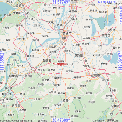
Huangmu GPS coordinates[2]
31° 4' 37.92" North, 118° 21' 31.464" East
| Map corner | latitude | longitude |
|---|---|---|
| Upper-left | 31.67749°, | 117.65562° |
| Center: | 31.0772°, | 118.35874° |
| Lower-right: | 30.47309°, | 119.06187° |
| Map W x H: | 133.9×133.9 km | = 83.2×83.2mi |
| max Lat: | 53.31946° ⇑44.6% North |
| Huangmu: | 31.0772° |
| min Lat: | ⇓55.4% South 18.22056° |
| min Long | Huangmu | max Long |
| 75.07348° | 118.35874° | 134.28917° |
| W 72.3%⇐ | ⇒27.7% E |
Elevation
Elevation of Huangmu is 8 m = 26 ft, and this is 476.8 m = 1564 ft below average elevation for this country.
| Max E: |
5622 m = 18445 ft | 92.7% |
| Avg. | 484.8 m = 1591 ft | |
| Huangmu | 8 m = 26 ft | |
Min E: |
-3 m = -10 ft | 7.3% |
See also: China elevation on elevation.city.
Geographical zone
Huangmu is located in North temperate zone (between Tropic of Cancer and the Arctic Circle). Distance of this Northern Tropic circle is 849.5 km =527.9 mi to South.| Distance of | km | miles | from Huangmu |
|---|---|---|---|
| North Pole | 6551.6 | 4071 | to North |
| Arctic Circle | 3945.7 | 2451.7 | to North |
| Tropic Cancer | 849.5 | 527.9 | to South |
| Equator | 3455.5 | 2147.1 | to South |


Nearby cities:
15 places around Huangmu: (largest is in red/bold)
• Dainan
13.5 km =8.4 mi,  30°
30°
• Donghe
14.3 km =8.9 mi,  139°
139°
• Eqiao
13.1 km =8.1 mi,  326°
326°
• Eshan
13.7 km =8.5 mi,  263°
263°
• Fanyang
15.7 km =9.8 mi,  273°
273°
• Jiafa
13.9 km =8.6 mi,  227°
227°
• Jishan
17.5 km =10.9 mi,  188°
188°
• Jiulian
13.7 km =8.5 mi,  170°
170°
• Kuihu
9.4 km =5.8 mi, 30°
• Pingpu
8.3 km =5.2 mi,  205°
205°
• Shigui
12.4 km =7.7 mi,  2°
2°
• Taifeng
10.5 km =6.5 mi,  108°
108°
• Taoxin
15.2 km =9.4 mi,  52°
52°
• Xihe
14.6 km =9.1 mi,  130°
130°
• Xuzhen
4.6 km =2.9 mi, 110°
Sources, notices
• [Note1] Compared only with cities in China existing in our database
• [Src1] Map data: © OpenStreetMap contributors (CC-BY-SA)
• [Src2] Other city data from geonames.org with taken over terms of usage.
• [Src3] Geographical zone / Annual Mean Temperature by Robert A. Rohde @ Wikipedia
