Hongtian geodata
Hongtian (Fujian) is a seat of a fourth-order administrative division; located in China in Asia/Shanghai (GMT+8) time zone. In our database, there are 1268 cities with bigger population. Compared to other cities in China, 82.9% of cities are located further ↑North; 67.5% of cities are located further ←West and 55.5% of cities have lower elevation than Hongtian. Note1


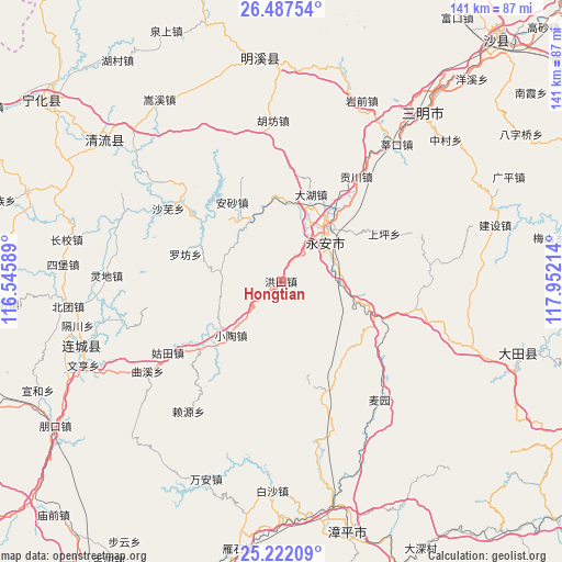
Hongtian GPS coordinates[2]
25° 51' 23.436" North, 117° 14' 56.436" East
| Map corner | latitude | longitude |
|---|---|---|
| Upper-left | 26.48754°, | 116.54589° |
| Center: | 25.85651°, | 117.24901° |
| Lower-right: | 25.22209°, | 117.95214° |
| Map W x H: | 140.7×140.7 km | = 87.4×87.4mi |
| max Lat: | 53.31946° ⇑82.9% North |
| Hongtian: | 25.85651° |
| min Lat: | ⇓17.1% South 18.22056° |
| min Long | Hongtian | max Long |
| 75.07348° | 117.24901° | 134.28917° |
| W 67.5%⇐ | ⇒32.5% E |
Elevation
Elevation of Hongtian is 211 m = 692 ft, and this is 273.8 m = 898 ft below average elevation for this country.
| Max E: |
5622 m = 18445 ft | 44.5% |
| Avg. | 484.8 m = 1591 ft | |
| Hongtian | 211 m = 692 ft | |
Min E: |
-3 m = -10 ft | 55.5% |
See also: China elevation on elevation.city.
Geographical zone
Hongtian is located in North temperate zone (between Tropic of Cancer and the Arctic Circle). Distance of this Northern Tropic circle is 269.1 km =167.2 mi to South.| Distance of | km | miles | from Hongtian |
|---|---|---|---|
| North Pole | 7132.1 | 4431.7 | to North |
| Arctic Circle | 4526.2 | 2812.4 | to North |
| Tropic Cancer | 269.1 | 167.2 | to South |
| Equator | 2875 | 1786.4 | to South |


Nearby cities:
15 places around Hongtian: (largest is in red/bold)
• Ansha
23.1 km =14.4 mi,  327°
327°
• Caoyuan
21.3 km =13.2 mi,  23°
23°
• Chishui
28.9 km =18 mi,  171°
171°
• Dahu
22.7 km =14.1 mi, 19°
• Gongchuan
32.3 km =20.1 mi,  35°
35°
• Gutian
33.5 km =20.8 mi,  237°
237°
• Huangli
14.1 km =8.8 mi,  64°
64°
• Jishan
13.1 km =8.1 mi,  31°
31°
• Luofang
24.9 km =15.5 mi,  284°
284°
• Shangping
28.4 km =17.6 mi,  65°
65°
• Shawu
33.4 km =20.8 mi,  302°
302°
• Shuangyang
29.8 km =18.5 mi,  158°
158°
• Xiaotao
18.8 km =11.7 mi,  222°
222°
• Xiyang
19.1 km =11.9 mi,  104°
104°
• Yong’an
17.9 km =11.1 mi, 39°
Sources, notices
• [Note1] Compared only with cities in China existing in our database
• [Src1] Map data: © OpenStreetMap contributors (CC-BY-SA)
• [Src2] Other city data from geonames.org with taken over terms of usage.
• [Src3] Geographical zone / Annual Mean Temperature by Robert A. Rohde @ Wikipedia
