Fu’an geodata
Fu’an (Fujian) is a seat of a third-order administrative division; located in China in Asia/Shanghai (GMT+8) time zone. With population of 71,053 people, there are 604 cities with bigger population in this country. Compared to other cities in China, 78.4% of cities are located further ↑North; 79.7% of cities are located further ←West and 56.5% of cities have lower elevation than Fu’an. Note1


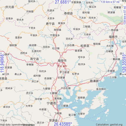
Fu’an GPS coordinates[2]
27° 3' 49.392" North, 119° 39' 10.08" East
| Map corner | latitude | longitude |
|---|---|---|
| Upper-left | 27.6881°, | 118.94968° |
| Center: | 27.06372°, | 119.6528° |
| Lower-right: | 26.43585°, | 120.35593° |
| Map W x H: | 139.2×139.2 km | = 86.5×86.5mi |
| max Lat: | 53.31946° ⇑78.4% North |
| Fu’an: | 27.06372° |
| min Lat: | ⇓21.6% South 18.22056° |
| min Long | Fu’an | max Long |
| 75.07348° | 119.6528° | 134.28917° |
| W 79.7%⇐ | ⇒20.3% E |
Elevation
Elevation of Fu’an is 221 m = 725 ft, and this is 263.8 m = 865 ft below average elevation for this country.
| Max E: |
5622 m = 18445 ft | 43.5% |
| Avg. | 484.8 m = 1591 ft | |
| Fu’an | 221 m = 725 ft | |
Min E: |
-3 m = -10 ft | 56.5% |
See also: Fu’an elevation on elevation.city.
Geographical zone
Fu’an is located in North temperate zone (between Tropic of Cancer and the Arctic Circle). Distance of this Northern Tropic circle is 403.3 km =250.6 mi to South.| Distance of | km | miles | from Fu’an |
|---|---|---|---|
| North Pole | 6997.9 | 4348.3 | to North |
| Arctic Circle | 4392 | 2729.1 | to North |
| Tropic Cancer | 403.3 | 250.6 | to South |
| Equator | 3009.2 | 1869.8 | to South |


Nearby cities:
15 places around Fu’an: (largest is in red/bold)
• Baiyang
20.8 km =12.9 mi,  93°
93°
• Banzhong
4.8 km =3 mi,  328°
328°
• Fuxi
22 km =13.7 mi,  50°
50°
• Gantang
16.1 km =10 mi,  186°
186°
• Huangbai
18.9 km =11.7 mi,  43°
43°
• Kangcuo
12.1 km =7.5 mi,  264°
264°
• Muyang
13 km =8.1 mi,  268°
268°
• Muyun
11 km =6.8 mi, 268°
• Shangbaishi
21.1 km =13.1 mi,  19°
19°
• Shekou
18.3 km =11.4 mi, 333°
• Tantou
15.7 km =9.8 mi,  2°
2°
• Wuqu
20.8 km =12.9 mi,  335°
335°
• Xibing
11.6 km =7.2 mi,  142°
142°
• Xitan
6.9 km =4.3 mi,  210°
210°
• Zhaizhong
21.6 km =13.4 mi,  71°
71°
Sources, notices
• [Note1] Compared only with cities in China existing in our database
• [Src1] Map data: © OpenStreetMap contributors (CC-BY-SA)
• [Src2] Other city data from geonames.org with taken over terms of usage.
• [Src3] Geographical zone / Annual Mean Temperature by Robert A. Rohde @ Wikipedia
