Tantou geodata
Tantou (Fujian) is a seat of a fourth-order administrative division; located in China in Asia/Shanghai (GMT+8) time zone. In our database, there are 1268 cities with bigger population. Compared to other cities in China, 77.8% of cities are located further ↑North; 79.8% of cities are located further ←West and 54.4% of cities have higher elevation than Tantou. Note1


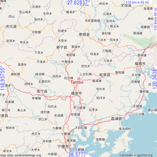
Tantou GPS coordinates[2]
27° 12' 17.244" North, 119° 39' 38.412" East
| Map corner | latitude | longitude |
|---|---|---|
| Upper-left | 27.82837°, | 118.95755° |
| Center: | 27.20479°, | 119.66067° |
| Lower-right: | 26.5777°, | 120.3638° |
| Map W x H: | 139.1×139.1 km | = 86.4×86.4mi |
| max Lat: | 53.31946° ⇑77.8% North |
| Tantou: | 27.20479° |
| min Lat: | ⇓22.2% South 18.22056° |
| min Long | Tantou | max Long |
| 75.07348° | 119.66067° | 134.28917° |
| W 79.8%⇐ | ⇒20.2% E |
Elevation
Elevation of Tantou is 135 m = 443 ft, and this is 349.8 m = 1148 ft below average elevation for this country.
| Max E: |
5622 m = 18445 ft | 54.4% |
| Avg. | 484.8 m = 1591 ft | |
| Tantou | 135 m = 443 ft | |
Min E: |
-3 m = -10 ft | 45.6% |
See also: China elevation on elevation.city.
Geographical zone
Tantou is located in North temperate zone (between Tropic of Cancer and the Arctic Circle). Distance of this Northern Tropic circle is 419 km =260.4 mi to South.| Distance of | km | miles | from Tantou |
|---|---|---|---|
| North Pole | 6982.2 | 4338.5 | to North |
| Arctic Circle | 4376.3 | 2719.3 | to North |
| Tropic Cancer | 419 | 260.4 | to South |
| Equator | 3024.9 | 1879.6 | to South |


Nearby cities:
15 places around Tantou: (largest is in red/bold)
• Banzhong
12 km =7.5 mi,  195°
195°
• Fankeng
13 km =8.1 mi,  28°
28°
• Fengyang
19.3 km =12 mi,  276°
276°
• Fuxi
16.3 km =10.1 mi,  95°
95°
• Fu’an
15.7 km =9.8 mi,  182°
182°
• Guihu
19.4 km =12.1 mi,  47°
47°
• Huangbai
12.4 km =7.7 mi, 99°
• Muyun
19.8 km =12.3 mi,  216°
216°
• Shangbaishi
7.6 km =4.7 mi,  55°
55°
• Shekou
8.9 km =5.5 mi, 275°
• Wuqu
9.9 km =6.2 mi,  288°
288°
• Xiaoyang
20.8 km =12.9 mi,  264°
264°
• Xietan
18.4 km =11.4 mi,  315°
315°
• Yingshan
16.5 km =10.3 mi, 57°
• Zhuguanlong
18 km =11.2 mi,  327°
327°
Sources, notices
• [Note1] Compared only with cities in China existing in our database
• [Src1] Map data: © OpenStreetMap contributors (CC-BY-SA)
• [Src2] Other city data from geonames.org with taken over terms of usage.
• [Src3] Geographical zone / Annual Mean Temperature by Robert A. Rohde @ Wikipedia
