Gutian geodata
Gutian (Fujian) is a seat of a fourth-order administrative division; located in China in Asia/Shanghai (GMT+8) time zone. In our database, there are 1268 cities with bigger population. Compared to other cities in China, 85.5% of cities are located further ↑North; 65.1% of cities are located further ←West and 80.4% of cities have lower elevation than Gutian. Note1


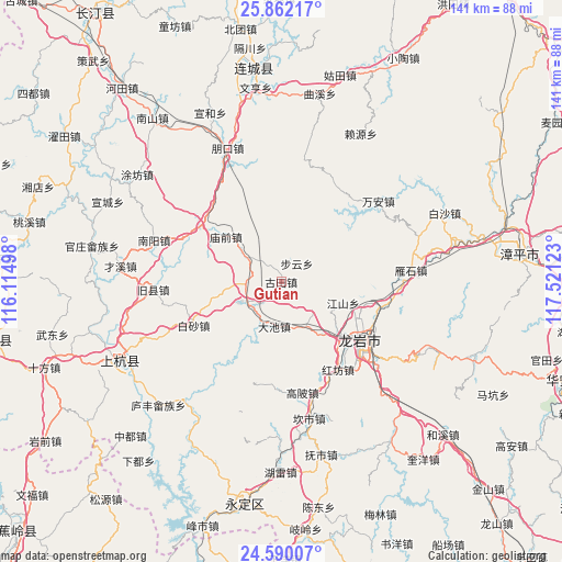
Gutian GPS coordinates[2]
25° 13' 40.008" North, 116° 49' 5.16" East
| Map corner | latitude | longitude |
|---|---|---|
| Upper-left | 25.86217°, | 116.11498° |
| Center: | 25.22778°, | 116.8181° |
| Lower-right: | 24.59007°, | 117.52123° |
| Map W x H: | 141.4×141.4 km | = 87.9×87.9mi |
| max Lat: | 53.31946° ⇑85.5% North |
| Gutian: | 25.22778° |
| min Lat: | ⇓14.5% South 18.22056° |
| min Long | Gutian | max Long |
| 75.07348° | 116.8181° | 134.28917° |
| W 65.1%⇐ | ⇒34.9% E |
Elevation
Elevation of Gutian is 717 m = 2352 ft, and this is 232.2 m = 762 ft above average elevation for this country.
| Max E: |
5622 m = 18445 ft | 19.6% |
| Gutian | 717 m 2352 ft | |
| Avg. | 484.8 m = 1591 ft | |
Min E: |
-3 m = -10 ft | 80.4% |
See also: China elevation on elevation.city.
Geographical zone
Gutian is located in North temperate zone (between Tropic of Cancer and the Arctic Circle). Distance of this Northern Tropic circle is 199.1 km =123.7 mi to South.| Distance of | km | miles | from Gutian |
|---|---|---|---|
| North Pole | 7202 | 4475.1 | to North |
| Arctic Circle | 4596.1 | 2855.9 | to North |
| Tropic Cancer | 199.1 | 123.7 | to South |
| Equator | 2805.1 | 1743 | to South |


Nearby cities:
15 places around Gutian: (largest is in red/bold)
• Baisha
24.6 km =15.3 mi,  243°
243°
• Buyun
6 km =3.7 mi,  37°
37°
• Hugang
25.8 km =16 mi,  185°
185°
• Jiangshan
16.5 km =10.3 mi,  108°
108°
• Jiaoyang
8.2 km =5.1 mi,  270°
270°
• Longmen
20.9 km =13 mi,  133°
133°
• Longyan
24.6 km =15.3 mi,  123°
123°
• Miaoqian
17.9 km =11.1 mi,  309°
309°
• Nanyang
26.1 km =16.2 mi,  148°
148°
• Tieshan
26.2 km =16.3 mi, 111°
• Xiaochi
11.5 km =7.1 mi,  143°
143°
• Xikou
23.2 km =14.4 mi,  218°
218°
• Xinquan
25.1 km =15.6 mi,  304°
304°
• Xipi
24.6 km =15.3 mi, 128°
• Yajin
11.6 km =7.2 mi, 191°
Sources, notices
• [Note1] Compared only with cities in China existing in our database
• [Src1] Map data: © OpenStreetMap contributors (CC-BY-SA)
• [Src2] Other city data from geonames.org with taken over terms of usage.
• [Src3] Geographical zone / Annual Mean Temperature by Robert A. Rohde @ Wikipedia
