Nanyang geodata
Nanyang (Fujian) is a seat of a fourth-order administrative division; located in China in Asia/Shanghai (GMT+8) time zone. In our database, there are 1268 cities with bigger population. Compared to other cities in China, 86.3% of cities are located further ↑North; 65.7% of cities are located further ←West and 68.8% of cities have lower elevation than Nanyang. Note1


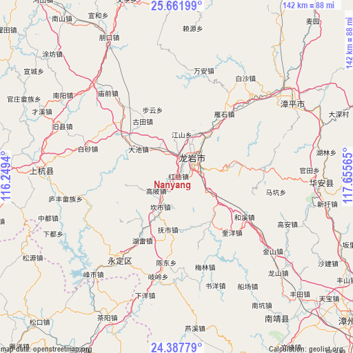
Nanyang GPS coordinates[2]
25° 1' 35.544" North, 116° 57' 9.072" East
| Map corner | latitude | longitude |
|---|---|---|
| Upper-left | 25.66199°, | 116.2494° |
| Center: | 25.02654°, | 116.95252° |
| Lower-right: | 24.38779°, | 117.65565° |
| Map W x H: | 141.7×141.7 km | = 88×88mi |
| max Lat: | 53.31946° ⇑86.3% North |
| Nanyang: | 25.02654° |
| min Lat: | ⇓13.7% South 18.22056° |
| min Long | Nanyang | max Long |
| 75.07348° | 116.95252° | 134.28917° |
| W 65.7%⇐ | ⇒34.3% E |
Elevation
Elevation of Nanyang is 390 m = 1280 ft, and this is 94.8 m = 311 ft below average elevation for this country.
| Max E: |
5622 m = 18445 ft | 31.2% |
| Avg. | 484.8 m = 1591 ft | |
| Nanyang | 390 m = 1280 ft | |
Min E: |
-3 m = -10 ft | 68.8% |
See also: China elevation on elevation.city.
Geographical zone
Nanyang is located in North temperate zone (between Tropic of Cancer and the Arctic Circle). Distance of this Northern Tropic circle is 176.8 km =109.9 mi to South.| Distance of | km | miles | from Nanyang |
|---|---|---|---|
| North Pole | 7224.4 | 4489 | to North |
| Arctic Circle | 4618.5 | 2869.8 | to North |
| Tropic Cancer | 176.8 | 109.9 | to South |
| Equator | 2782.7 | 1729.1 | to South |


Nearby cities:
15 places around Nanyang: (largest is in red/bold)
• Caoxi
9.3 km =5.8 mi,  58°
58°
• Dongxiao
5.6 km =3.5 mi,  87°
87°
• Fushi
21.4 km =13.3 mi,  189°
189°
• Gaobei
9.8 km =6.1 mi,  236°
236°
• Hugang
16.4 km =10.2 mi,  258°
258°
• Jiangshan
17.2 km =10.7 mi,  6°
6°
• Kanshi
13.6 km =8.5 mi,  208°
208°
• Longmen
8 km =5 mi, 11°
• Longyan
11.4 km =7.1 mi,  38°
38°
• Peifeng
13.4 km =8.3 mi, 185°
• Tangbao
22.1 km =13.7 mi,  219°
219°
• Tieshan
16.6 km =10.3 mi, 40°
• Xiaochi
14.7 km =9.1 mi,  332°
332°
• Xipi
9.3 km =5.8 mi, 38°
• Yajin
19.4 km =12.1 mi,  304°
304°
Sources, notices
• [Note1] Compared only with cities in China existing in our database
• [Src1] Map data: © OpenStreetMap contributors (CC-BY-SA)
• [Src2] Other city data from geonames.org with taken over terms of usage.
• [Src3] Geographical zone / Annual Mean Temperature by Robert A. Rohde @ Wikipedia
