Guantian geodata
Guantian (Jiangxi) is a seat of a fourth-order administrative division; located in China in Asia/Shanghai (GMT+8) time zone. In our database, there are 1268 cities with bigger population. Compared to other cities in China, 78.4% of cities are located further ↑North; 52.4% of cities are located further ←West and 59.5% of cities have higher elevation than Guantian. Note1


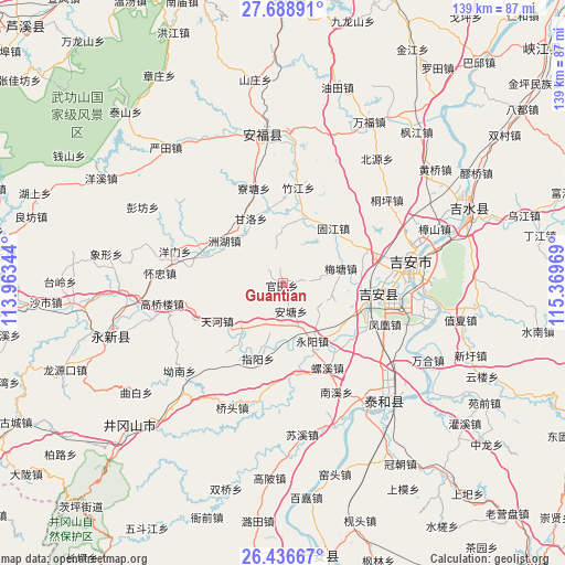
Guantian GPS coordinates[2]
27° 3' 52.344" North, 114° 39' 59.616" East
| Map corner | latitude | longitude |
|---|---|---|
| Upper-left | 27.68891°, | 113.96344° |
| Center: | 27.06454°, | 114.66656° |
| Lower-right: | 26.43667°, | 115.36969° |
| Map W x H: | 139.2×139.2 km | = 86.5×86.5mi |
| max Lat: | 53.31946° ⇑78.4% North |
| Guantian: | 27.06454° |
| min Lat: | ⇓21.6% South 18.22056° |
| min Long | Guantian | max Long |
| 75.07348° | 114.66656° | 134.28917° |
| W 52.4%⇐ | ⇒47.6% E |
Elevation
Elevation of Guantian is 101 m = 331 ft, and this is 383.8 m = 1259 ft below average elevation for this country.
| Max E: |
5622 m = 18445 ft | 59.5% |
| Avg. | 484.8 m = 1591 ft | |
| Guantian | 101 m = 331 ft | |
Min E: |
-3 m = -10 ft | 40.5% |
See also: China elevation on elevation.city.
Geographical zone
Guantian is located in North temperate zone (between Tropic of Cancer and the Arctic Circle). Distance of this Northern Tropic circle is 403.4 km =250.7 mi to South.| Distance of | km | miles | from Guantian |
|---|---|---|---|
| North Pole | 6997.8 | 4348.2 | to North |
| Arctic Circle | 4391.9 | 2729 | to North |
| Tropic Cancer | 403.4 | 250.7 | to South |
| Equator | 3009.3 | 1869.9 | to South |


Nearby cities:
15 places around Guantian: (largest is in red/bold)
• Antang
7.2 km =4.5 mi,  168°
168°
• Denglong
10.2 km =6.3 mi,  124°
124°
• Dunhou
23.2 km =14.4 mi,  94°
94°
• Ganluo
17.9 km =11.1 mi,  333°
333°
• Gujiang
18.3 km =11.4 mi,  41°
41°
• Hebu
30 km =18.6 mi,  82°
82°
• Jintian
24.5 km =15.2 mi,  292°
292°
• Liaotang
24.5 km =15.2 mi,  342°
342°
• Litian
17.5 km =10.9 mi,  20°
20°
• Meitang
14.4 km =8.9 mi, 75°
• Qulai
19.2 km =11.9 mi, 91°
• Xingqiao
22.2 km =13.8 mi,  67°
67°
• Yangmen
27.8 km =17.3 mi, 286°
• Zhouhu
17.9 km =11.1 mi,  306°
306°
• Zhujiang
23.9 km =14.9 mi,  9°
9°
Sources, notices
• [Note1] Compared only with cities in China existing in our database
• [Src1] Map data: © OpenStreetMap contributors (CC-BY-SA)
• [Src2] Other city data from geonames.org with taken over terms of usage.
• [Src3] Geographical zone / Annual Mean Temperature by Robert A. Rohde @ Wikipedia
