Gongqiao geodata
Gongqiao (Fujian) is a seat of a fourth-order administrative division; located in China in Asia/Shanghai (GMT+8) time zone. In our database, there are 1268 cities with bigger population. Compared to other cities in China, 85.4% of cities are located further ↑North; 67.9% of cities are located further ←West and 68.1% of cities have lower elevation than Gongqiao. Note1


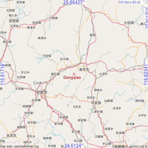
Gongqiao GPS coordinates[2]
25° 15' 0" North, 117° 19' 13.008" East
| Map corner | latitude | longitude |
|---|---|---|
| Upper-left | 25.88427°, | 116.61716° |
| Center: | 25.25°, | 117.32028° |
| Lower-right: | 24.6124°, | 118.02341° |
| Map W x H: | 141.4×141.4 km | = 87.9×87.9mi |
| max Lat: | 53.31946° ⇑85.4% North |
| Gongqiao: | 25.25° |
| min Lat: | ⇓14.6% South 18.22056° |
| min Long | Gongqiao | max Long |
| 75.07348° | 117.32028° | 134.28917° |
| W 67.9%⇐ | ⇒32.1% E |
Elevation
Elevation of Gongqiao is 379 m = 1243 ft, and this is 105.8 m = 347 ft below average elevation for this country.
| Max E: |
5622 m = 18445 ft | 31.9% |
| Avg. | 484.8 m = 1591 ft | |
| Gongqiao | 379 m = 1243 ft | |
Min E: |
-3 m = -10 ft | 68.1% |
See also: China elevation on elevation.city.
Geographical zone
Gongqiao is located in North temperate zone (between Tropic of Cancer and the Arctic Circle). Distance of this Northern Tropic circle is 201.6 km =125.3 mi to South.| Distance of | km | miles | from Gongqiao |
|---|---|---|---|
| North Pole | 7199.5 | 4473.6 | to North |
| Arctic Circle | 4593.6 | 2854.3 | to North |
| Tropic Cancer | 201.6 | 125.3 | to South |
| Equator | 2807.5 | 1744.5 | to South |


Nearby cities:
15 places around Gongqiao: (largest is in red/bold)
• Baisha
18.7 km =11.6 mi,  328°
328°
• Futian
29.5 km =18.3 mi,  86°
86°
• Guantian
27.4 km =17 mi,  143°
143°
• Heping
14.4 km =8.9 mi,  45°
45°
• Hulin
27.4 km =17 mi,  122°
122°
• Jingchen
10.2 km =6.3 mi,  59°
59°
• Luzhi
14.5 km =9 mi,  75°
75°
• Nanyang
17.2 km =10.7 mi,  8°
8°
• Suban
8.6 km =5.3 mi, 327°
• Tieshan
28.9 km =18 mi,  245°
245°
• Xiyuan
10.3 km =6.4 mi,  24°
24°
• Yanshan
17.5 km =10.9 mi,  234°
234°
• Yanshi
18.3 km =11.4 mi,  271°
271°
• Yongfu
20.6 km =12.8 mi,  184°
184°
• Zhangping
11 km =6.8 mi, 59°
Sources, notices
• [Note1] Compared only with cities in China existing in our database
• [Src1] Map data: © OpenStreetMap contributors (CC-BY-SA)
• [Src2] Other city data from geonames.org with taken over terms of usage.
• [Src3] Geographical zone / Annual Mean Temperature by Robert A. Rohde @ Wikipedia
