Baisha geodata
Baisha (Fujian) is a seat of a fourth-order administrative division; located in China in Asia/Shanghai (GMT+8) time zone. In our database, there are 1268 cities with bigger population. Compared to other cities in China, 84.7% of cities are located further ↑North; 67.3% of cities are located further ←West and 64.4% of cities have lower elevation than Baisha. Note1


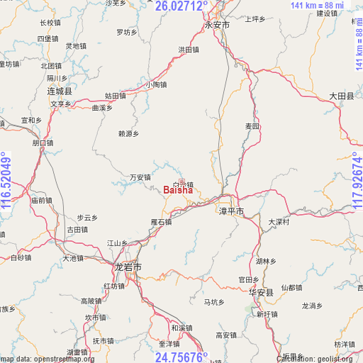
Baisha GPS coordinates[2]
25° 23' 36.996" North, 117° 13' 24.996" East
| Map corner | latitude | longitude |
|---|---|---|
| Upper-left | 26.02712°, | 116.52049° |
| Center: | 25.39361°, | 117.22361° |
| Lower-right: | 24.75676°, | 117.92674° |
| Map W x H: | 141.3×141.3 km | = 87.8×87.8mi |
| max Lat: | 53.31946° ⇑84.7% North |
| Baisha: | 25.39361° |
| min Lat: | ⇓15.3% South 18.22056° |
| min Long | Baisha | max Long |
| 75.07348° | 117.22361° | 134.28917° |
| W 67.3%⇐ | ⇒32.7% E |
Elevation
Elevation of Baisha is 316 m = 1037 ft, and this is 168.8 m = 554 ft below average elevation for this country.
| Max E: |
5622 m = 18445 ft | 35.6% |
| Avg. | 484.8 m = 1591 ft | |
| Baisha | 316 m = 1037 ft | |
Min E: |
-3 m = -10 ft | 64.4% |
See also: China elevation on elevation.city.
Geographical zone
Baisha is located in North temperate zone (between Tropic of Cancer and the Arctic Circle). Distance of this Northern Tropic circle is 217.6 km =135.2 mi to South.| Distance of | km | miles | from Baisha |
|---|---|---|---|
| North Pole | 7183.6 | 4463.7 | to North |
| Arctic Circle | 4577.7 | 2844.5 | to North |
| Tropic Cancer | 217.6 | 135.2 | to South |
| Equator | 2823.5 | 1754.4 | to South |


Nearby cities:
15 places around Baisha: (largest is in red/bold)
• Chishui
23.8 km =14.8 mi,  16°
16°
• Gongqiao
18.7 km =11.6 mi,  148°
148°
• Heping
20.8 km =12.9 mi,  106°
106°
• Jingchen
21.4 km =13.3 mi,  120°
120°
• Laiyuan
27.8 km =17.3 mi,  312°
312°
• Luzhi
26.8 km =16.7 mi, 117°
• Nanyang
12.3 km =7.6 mi,  85°
85°
• Shuangyang
27.4 km =17 mi,  29°
29°
• Suban
10.1 km =6.3 mi, 149°
• Tieshan
32.6 km =20.3 mi,  210°
210°
• Wan’an
16.7 km =10.4 mi,  275°
275°
• Xiyuan
15.4 km =9.6 mi, 115°
• Yanshan
26.5 km =16.5 mi,  189°
189°
• Yanshi
17.6 km =10.9 mi, 209°
• Zhangping
21.9 km =13.6 mi, 118°
Sources, notices
• [Note1] Compared only with cities in China existing in our database
• [Src1] Map data: © OpenStreetMap contributors (CC-BY-SA)
• [Src2] Other city data from geonames.org with taken over terms of usage.
• [Src3] Geographical zone / Annual Mean Temperature by Robert A. Rohde @ Wikipedia
