Gantang geodata
Gantang (Anhui) is a seat of a third-order administrative division; located in China in Asia/Shanghai (GMT+8) time zone. In our database, there are 1268 cities with bigger population. Compared to other cities in China, 51.2% of cities are located further ↑North; 71.1% of cities are located further ←West and 51.9% of cities have lower elevation than Gantang. Note1


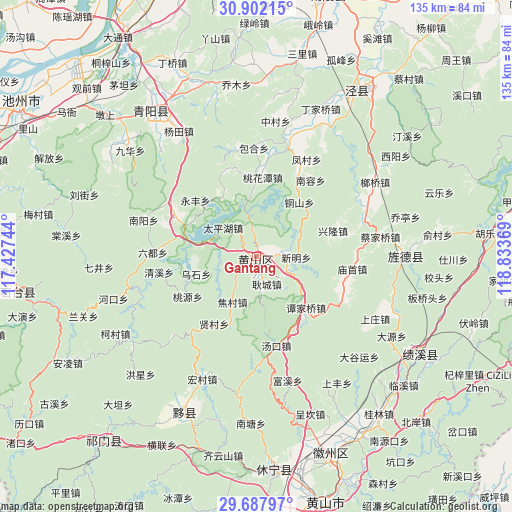
Gantang GPS coordinates[2]
30° 17' 48.984" North, 118° 7' 50.016" East
| Map corner | latitude | longitude |
|---|---|---|
| Upper-left | 30.90215°, | 117.42744° |
| Center: | 30.29694°, | 118.13056° |
| Lower-right: | 29.68797°, | 118.83369° |
| Map W x H: | 135×135 km | = 83.9×83.9mi |
| max Lat: | 53.31946° ⇑51.2% North |
| Gantang: | 30.29694° |
| min Lat: | ⇓48.8% South 18.22056° |
| min Long | Gantang | max Long |
| 75.07348° | 118.13056° | 134.28917° |
| W 71.1%⇐ | ⇒28.9% E |
Elevation
Elevation of Gantang is 180 m = 591 ft, and this is 304.8 m = 1000 ft below average elevation for this country.
| Max E: |
5622 m = 18445 ft | 48.1% |
| Avg. | 484.8 m = 1591 ft | |
| Gantang | 180 m = 591 ft | |
Min E: |
-3 m = -10 ft | 51.9% |
See also: China elevation on elevation.city.
Geographical zone
Gantang is located in North temperate zone (between Tropic of Cancer and the Arctic Circle). Distance of this Northern Tropic circle is 762.8 km =474 mi to South.| Distance of | km | miles | from Gantang |
|---|---|---|---|
| North Pole | 6638.4 | 4124.9 | to North |
| Arctic Circle | 4032.5 | 2505.7 | to North |
| Tropic Cancer | 762.8 | 474 | to South |
| Equator | 3368.7 | 2093.2 | to South |


Nearby cities:
15 places around Gantang: (largest is in red/bold)
• Gengcheng
7.9 km =4.9 mi,  159°
159°
• Jiaocun
13.2 km =8.2 mi,  207°
207°
• Longmen
8.7 km =5.4 mi,  349°
349°
• Pinghu
12.5 km =7.8 mi,  286°
286°
• Sankou
9 km =5.6 mi,  117°
117°
• Taipinghu
11.7 km =7.3 mi,  311°
311°
• Tanjiaqiao
19 km =11.8 mi,  135°
135°
• Taohuatan
21.4 km =13.3 mi,  3°
3°
• Tongshan
18.1 km =11.2 mi,  38°
38°
• Xiancun
21 km =13 mi, 212°
• Xianyuan
6.8 km =4.2 mi,  81°
81°
• Xinfeng
23.6 km =14.7 mi, 347°
• Xinglong
21.3 km =13.2 mi,  71°
71°
• Xinhua
19 km =11.8 mi,  332°
332°
• Xinming
11.7 km =7.3 mi, 68°
Sources, notices
• [Note1] Compared only with cities in China existing in our database
• [Src1] Map data: © OpenStreetMap contributors (CC-BY-SA)
• [Src2] Other city data from geonames.org with taken over terms of usage.
• [Src3] Geographical zone / Annual Mean Temperature by Robert A. Rohde @ Wikipedia
