Xianyuan geodata
Xianyuan (Anhui) is a seat of a fourth-order administrative division; located in China in Asia/Shanghai (GMT+8) time zone. In our database, there are 1268 cities with bigger population. Compared to other cities in China, 51.2% of cities are located further ↑North; 71.5% of cities are located further ←West and 53.8% of cities have higher elevation than Xianyuan. Note1


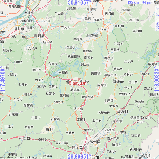
Xianyuan GPS coordinates[2]
30° 18' 19.512" North, 118° 12' 0.72" East
| Map corner | latitude | longitude |
|---|---|---|
| Upper-left | 30.91057°, | 117.49708° |
| Center: | 30.30542°, | 118.2002° |
| Lower-right: | 29.69651°, | 118.90333° |
| Map W x H: | 135×135 km | = 83.9×83.9mi |
| max Lat: | 53.31946° ⇑51.2% North |
| Xianyuan: | 30.30542° |
| min Lat: | ⇓48.8% South 18.22056° |
| min Long | Xianyuan | max Long |
| 75.07348° | 118.2002° | 134.28917° |
| W 71.5%⇐ | ⇒28.5% E |
Elevation
Elevation of Xianyuan is 138 m = 453 ft, and this is 346.8 m = 1138 ft below average elevation for this country.
| Max E: |
5622 m = 18445 ft | 53.8% |
| Avg. | 484.8 m = 1591 ft | |
| Xianyuan | 138 m = 453 ft | |
Min E: |
-3 m = -10 ft | 46.2% |
See also: China elevation on elevation.city.
Geographical zone
Xianyuan is located in North temperate zone (between Tropic of Cancer and the Arctic Circle). Distance of this Northern Tropic circle is 763.7 km =474.5 mi to South.| Distance of | km | miles | from Xianyuan |
|---|---|---|---|
| North Pole | 6637.4 | 4124.3 | to North |
| Arctic Circle | 4031.5 | 2505.1 | to North |
| Tropic Cancer | 763.7 | 474.5 | to South |
| Equator | 3369.6 | 2093.8 | to South |


Nearby cities:
15 places around Xianyuan: (largest is in red/bold)
• Baidi
19.9 km =12.4 mi,  123°
123°
• Gantang
6.8 km =4.2 mi,  261°
261°
• Gengcheng
9.2 km =5.7 mi,  205°
205°
• Jiaocun
18 km =11.2 mi,  225°
225°
• Longmen
11.2 km =7 mi,  312°
312°
• Miaoshou
18.9 km =11.7 mi,  103°
103°
• Pinghu
18.9 km =11.7 mi,  277°
277°
• Sankou
5.3 km =3.3 mi,  165°
165°
• Suncun
20.5 km =12.7 mi,  86°
86°
• Taipinghu
16.9 km =10.5 mi,  294°
294°
• Tanjiaqiao
16 km =9.9 mi,  155°
155°
• Taohuatan
21 km =13 mi,  345°
345°
• Tongshan
14 km =8.7 mi,  19°
19°
• Xinglong
14.7 km =9.1 mi,  67°
67°
• Xinming
5.4 km =3.4 mi,  51°
51°
Sources, notices
• [Note1] Compared only with cities in China existing in our database
• [Src1] Map data: © OpenStreetMap contributors (CC-BY-SA)
• [Src2] Other city data from geonames.org with taken over terms of usage.
• [Src3] Geographical zone / Annual Mean Temperature by Robert A. Rohde @ Wikipedia
