Ganpu geodata
Ganpu (Zhejiang) is a seat of a fourth-order administrative division; located in China in Asia/Shanghai (GMT+8) time zone. In our database, there are 1268 cities with bigger population. Compared to other cities in China, 50.4% of cities are located further ↑North; 87.3% of cities are located further ←West and 89.9% of cities have higher elevation than Ganpu. Note1


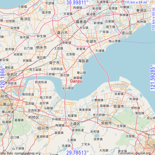
Ganpu GPS coordinates[2]
30° 23' 36.6" North, 120° 53' 22.992" East
| Map corner | latitude | longitude |
|---|---|---|
| Upper-left | 30.99811°, | 120.1866° |
| Center: | 30.3935°, | 120.88972° |
| Lower-right: | 29.78513°, | 121.59285° |
| Map W x H: | 134.9×134.9 km | = 83.8×83.8mi |
| max Lat: | 53.31946° ⇑50.4% North |
| Ganpu: | 30.3935° |
| min Lat: | ⇓49.6% South 18.22056° |
| min Long | Ganpu | max Long |
| 75.07348° | 120.88972° | 134.28917° |
| W 87.3%⇐ | ⇒12.7% E |
Elevation
Elevation of Ganpu is 10 m = 33 ft, and this is 474.8 m = 1558 ft below average elevation for this country.
| Max E: |
5622 m = 18445 ft | 89.9% |
| Avg. | 484.8 m = 1591 ft | |
| Ganpu | 10 m = 33 ft | |
Min E: |
-3 m = -10 ft | 10.1% |
See also: China elevation on elevation.city.
Geographical zone
Ganpu is located in North temperate zone (between Tropic of Cancer and the Arctic Circle). Distance of this Northern Tropic circle is 773.5 km =480.6 mi to South.| Distance of | km | miles | from Ganpu |
|---|---|---|---|
| North Pole | 6627.6 | 4118.2 | to North |
| Arctic Circle | 4021.7 | 2499 | to North |
| Tropic Cancer | 773.5 | 480.6 | to South |
| Equator | 3379.4 | 2099.9 | to South |


Nearby cities:
15 places around Ganpu: (largest is in red/bold)
• Baibu
19.7 km =12.2 mi,  326°
326°
• Dingqiao
24.3 km =15.1 mi,  277°
277°
• Gaibei
28.2 km =17.5 mi,  180°
180°
• Haining
25.1 km =15.6 mi,  309°
309°
• Huangwan
9.5 km =5.9 mi,  252°
252°
• Maqiao
20 km =12.4 mi,  293°
293°
• Qinshan
5.6 km =3.5 mi,  34°
34°
• Shendang
21.5 km =13.4 mi,  342°
342°
• Tongyuan
8.5 km =5.3 mi,  324°
324°
• Wuyuan
14.7 km =9.1 mi,  22°
22°
• Xinhuang
25.4 km =15.8 mi,  5°
5°
• Xitangqiao
25.5 km =15.8 mi, 20°
• Yangjialusanqiu
25.8 km =16 mi,  138°
138°
• Yuanhua
11.6 km =7.2 mi, 281°
• Yucheng
16.1 km =10 mi,  347°
347°
Sources, notices
• [Note1] Compared only with cities in China existing in our database
• [Src1] Map data: © OpenStreetMap contributors (CC-BY-SA)
• [Src2] Other city data from geonames.org with taken over terms of usage.
• [Src3] Geographical zone / Annual Mean Temperature by Robert A. Rohde @ Wikipedia
