Shendang geodata
Shendang (Zhejiang) is a seat of a fourth-order administrative division; located in China in Asia/Shanghai (GMT+8) time zone. In our database, there are 1268 cities with bigger population. Compared to other cities in China, 50.9% of cities are located further ↓South; 86.9% of cities are located further ←West and 88.7% of cities have higher elevation than Shendang. Note1


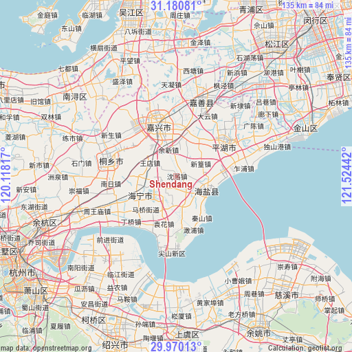
Shendang GPS coordinates[2]
30° 34' 38.496" North, 120° 49' 16.644" East
| Map corner | latitude | longitude |
|---|---|---|
| Upper-left | 31.18081°, | 120.11817° |
| Center: | 30.57736°, | 120.82129° |
| Lower-right: | 29.97013°, | 121.52442° |
| Map W x H: | 134.6×134.6 km | = 83.6×83.6mi |
| max Lat: | 53.31946° ⇑49.1% North |
| Shendang: | 30.57736° |
| min Lat: | ⇓50.9% South 18.22056° |
| min Long | Shendang | max Long |
| 75.07348° | 120.82129° | 134.28917° |
| W 86.9%⇐ | ⇒13.1% E |
Elevation
Elevation of Shendang is 11 m = 36 ft, and this is 473.8 m = 1554 ft below average elevation for this country.
| Max E: |
5622 m = 18445 ft | 88.7% |
| Avg. | 484.8 m = 1591 ft | |
| Shendang | 11 m = 36 ft | |
Min E: |
-3 m = -10 ft | 11.3% |
See also: China elevation on elevation.city.
Geographical zone
Shendang is located in North temperate zone (between Tropic of Cancer and the Arctic Circle). Distance of this Northern Tropic circle is 794 km =493.4 mi to South.| Distance of | km | miles | from Shendang |
|---|---|---|---|
| North Pole | 6607.2 | 4105.5 | to North |
| Arctic Circle | 4001.3 | 2486.3 | to North |
| Tropic Cancer | 794 | 493.4 | to South |
| Equator | 3399.9 | 2112.6 | to South |


Nearby cities:
15 places around Shendang: (largest is in red/bold)
• Baibu
5.7 km =3.5 mi,  226°
226°
• Caoqiao
17.6 km =10.9 mi,  53°
53°
• Fengqiao
9.8 km =6.1 mi,  18°
18°
• Haining
13.7 km =8.5 mi,  250°
250°
• Maqiao
17.2 km =10.7 mi,  223°
223°
• Qinshan
18.6 km =11.6 mi,  148°
148°
• Tongyuan
13.6 km =8.5 mi,  172°
172°
• Wangdian
11.4 km =7.1 mi,  297°
297°
• Wuyuan
14 km =8.7 mi,  119°
119°
• Xinfeng
17.3 km =10.7 mi,  32°
32°
• Xinhuang
10.2 km =6.3 mi,  61°
61°
• Xitangqiao
15.9 km =9.9 mi,  77°
77°
• Yuanhua
18.7 km =11.6 mi,  194°
194°
• Yucheng
5.6 km =3.5 mi, 147°
• Yuxin
10.6 km =6.6 mi,  342°
342°
Sources, notices
• [Note1] Compared only with cities in China existing in our database
• [Src1] Map data: © OpenStreetMap contributors (CC-BY-SA)
• [Src2] Other city data from geonames.org with taken over terms of usage.
• [Src3] Geographical zone / Annual Mean Temperature by Robert A. Rohde @ Wikipedia
