Gangshangji geodata
Gangshangji (Jiangxi) is a seat of a fourth-order administrative division; located in China in Asia/Shanghai (GMT+8) time zone. In our database, there are 1268 cities with bigger population. Compared to other cities in China, 73.2% of cities are located further ↑North; 63.2% of cities are located further ←West and 74.1% of cities have higher elevation than Gangshangji. Note1


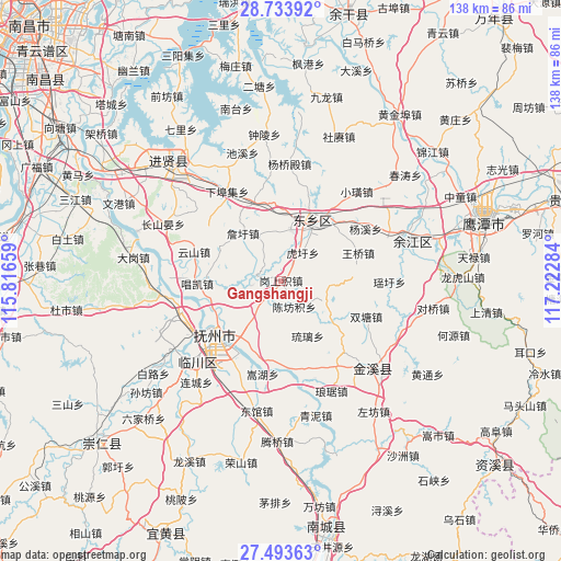
Gangshangji GPS coordinates[2]
28° 6' 56.052" North, 116° 31' 10.956" East
| Map corner | latitude | longitude |
|---|---|---|
| Upper-left | 28.73392°, | 115.81659° |
| Center: | 28.11557°, | 116.51971° |
| Lower-right: | 27.49363°, | 117.22284° |
| Map W x H: | 137.9×137.9 km | = 85.7×85.7mi |
| max Lat: | 53.31946° ⇑73.2% North |
| Gangshangji: | 28.11557° |
| min Lat: | ⇓26.8% South 18.22056° |
| min Long | Gangshangji | max Long |
| 75.07348° | 116.51971° | 134.28917° |
| W 63.2%⇐ | ⇒36.8% E |
Elevation
Elevation of Gangshangji is 39 m = 128 ft, and this is 445.8 m = 1463 ft below average elevation for this country.
| Max E: |
5622 m = 18445 ft | 74.1% |
| Avg. | 484.8 m = 1591 ft | |
| Gangshangji | 39 m = 128 ft | |
Min E: |
-3 m = -10 ft | 25.9% |
See also: China elevation on elevation.city.
Geographical zone
Gangshangji is located in North temperate zone (between Tropic of Cancer and the Arctic Circle). Distance of this Northern Tropic circle is 520.2 km =323.2 mi to South.| Distance of | km | miles | from Gangshangji |
|---|---|---|---|
| North Pole | 6880.9 | 4275.6 | to North |
| Arctic Circle | 4275 | 2656.4 | to North |
| Tropic Cancer | 520.2 | 323.2 | to South |
| Equator | 3126.2 | 1942.5 | to South |


Nearby cities:
15 places around Gangshangji: (largest is in red/bold)
• Chenfangji
7.1 km =4.4 mi,  151°
151°
• Dengjiaxiang
15.7 km =9.8 mi,  15°
15°
• Heshi
16.7 km =10.4 mi,  129°
129°
• Huxu
8.7 km =5.4 mi,  38°
38°
• Jinggonglu
20.9 km =13 mi,  230°
230°
• Lixu
12.2 km =7.6 mi,  115°
115°
• Maxu
5.5 km =3.4 mi,  291°
291°
• Qiaodong
20.1 km =12.5 mi, 230°
• Qiligang
15 km =9.3 mi,  218°
218°
• Taiyang
7.2 km =4.5 mi,  214°
214°
• Wangqiao
20.2 km =12.6 mi,  70°
70°
• Xidajie
21 km =13 mi, 231°
• Xushangqiao
12.9 km =8 mi,  11°
11°
• Yaqian
20.5 km =12.7 mi,  341°
341°
• Zhanxu
15 km =9.3 mi,  320°
320°
Sources, notices
• [Note1] Compared only with cities in China existing in our database
• [Src1] Map data: © OpenStreetMap contributors (CC-BY-SA)
• [Src2] Other city data from geonames.org with taken over terms of usage.
• [Src3] Geographical zone / Annual Mean Temperature by Robert A. Rohde @ Wikipedia
