Gangkou geodata
Gangkou (Guangdong) is a seat of a fourth-order administrative division; located in China in Asia/Shanghai (GMT+8) time zone. In our database, there are 1268 cities with bigger population. Compared to other cities in China, 96.1% of cities are located further ↑North; 55.1% of cities are located further →East and 99.4% of cities have higher elevation than Gangkou. Note1


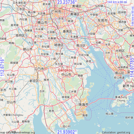
Gangkou GPS coordinates[2]
22° 35' 22.992" North, 113° 22' 28.992" East
| Map corner | latitude | longitude |
|---|---|---|
| Upper-left | 23.23736°, | 112.6716° |
| Center: | 22.58972°, | 113.37472° |
| Lower-right: | 21.93902°, | 114.07785° |
| Map W x H: | 144.4×144.4 km | = 89.7×89.7mi |
| max Lat: | 53.31946° ⇑96.1% North |
| Gangkou: | 22.58972° |
| min Lat: | ⇓3.9% South 18.22056° |
| min Long | Gangkou | max Long |
| 75.07348° | 113.37472° | 134.28917° |
| W 44.9%⇐ | ⇒55.1% E |
Elevation
Elevation of Gangkou is 2 m = 7 ft, and this is 482.8 m = 1584 ft below average elevation for this country.
| Max E: |
5622 m = 18445 ft | 99.4% |
| Avg. | 484.8 m = 1591 ft | |
| Gangkou | 2 m = 7 ft | |
Min E: |
-3 m = -10 ft | 0.6% |
See also: China elevation on elevation.city.
Geographical zone
Gangkou is located in North Torrid zone (between Equator and Tropic of Cancer). Distance of this Northern Tropic circle is 94.2 km =58.5 mi to North.| Distance of | km | miles | from Gangkou |
|---|---|---|---|
| North Pole | 7495.3 | 4657.4 | to North |
| Arctic Circle | 4889.4 | 3038.1 | to North |
| Tropic Cancer | 94.2 | 58.5 | to North |
| Equator | 2511.7 | 1560.7 | to South |


Nearby cities:
15 places around Gangkou: (largest is in red/bold)
• Dayong
16.1 km =10 mi,  214°
214°
• Dongqu
8.6 km =5.3 mi,  159°
159°
• Dongsheng
9.6 km =6 mi,  292°
292°
• Fusha
8.6 km =5.3 mi,  339°
339°
• Henglan
14.4 km =8.9 mi,  244°
244°
• Huancheng
13.1 km =8.1 mi,  180°
180°
• Huangpu
14.7 km =9.1 mi, 344°
• Minzhong
12.2 km =7.6 mi,  71°
71°
• Nantou
16.9 km =10.5 mi,  330°
330°
• Sanjiao
11.9 km =7.4 mi,  27°
27°
• Shaxi
11.7 km =7.3 mi,  216°
216°
• Shiqi
8.2 km =5.1 mi,  172°
172°
• Xiqu
7.9 km =4.9 mi,  193°
193°
• Zhongshan
7.4 km =4.6 mi, 176°
• Zhongshangang
11.9 km =7.4 mi,  103°
103°
Sources, notices
• [Note1] Compared only with cities in China existing in our database
• [Src1] Map data: © OpenStreetMap contributors (CC-BY-SA)
• [Src2] Other city data from geonames.org with taken over terms of usage.
• [Src3] Geographical zone / Annual Mean Temperature by Robert A. Rohde @ Wikipedia
