Huangpu geodata
Huangpu (Guangdong) is a seat of a fourth-order administrative division; located in China in Asia/Shanghai (GMT+8) time zone. In our database, there are 1268 cities with bigger population. Compared to other cities in China, 95.6% of cities are located further ↑North; 55.4% of cities are located further →East and 98.9% of cities have higher elevation than Huangpu. Note1


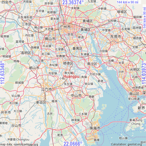
Huangpu GPS coordinates[2]
22° 43' 0.156" North, 113° 20' 11.76" East
| Map corner | latitude | longitude |
|---|---|---|
| Upper-left | 23.36374°, | 112.63348° |
| Center: | 22.71671°, | 113.3366° |
| Lower-right: | 22.0666°, | 114.03973° |
| Map W x H: | 144.2×144.2 km | = 89.6×89.6mi |
| max Lat: | 53.31946° ⇑95.6% North |
| Huangpu: | 22.71671° |
| min Lat: | ⇓4.4% South 18.22056° |
| min Long | Huangpu | max Long |
| 75.07348° | 113.3366° | 134.28917° |
| W 44.6%⇐ | ⇒55.4% E |
Elevation
Elevation of Huangpu is 3 m = 10 ft, and this is 481.8 m = 1581 ft below average elevation for this country.
| Max E: |
5622 m = 18445 ft | 98.9% |
| Avg. | 484.8 m = 1591 ft | |
| Huangpu | 3 m = 10 ft | |
Min E: |
-3 m = -10 ft | 1.1% |
See also: China elevation on elevation.city.
Geographical zone
Huangpu is located in North Torrid zone (between Equator and Tropic of Cancer). Distance of this Northern Tropic circle is 80.1 km =49.8 mi to North.| Distance of | km | miles | from Huangpu |
|---|---|---|---|
| North Pole | 7481.2 | 4648.6 | to North |
| Arctic Circle | 4875.3 | 3029.4 | to North |
| Tropic Cancer | 80.1 | 49.8 | to North |
| Equator | 2525.9 | 1569.5 | to South |


Nearby cities:
15 places around Huangpu: (largest is in red/bold)
• Dagang
12 km =7.5 mi,  34°
34°
• Daliang
16.4 km =10.2 mi,  327°
327°
• Dongfeng
9.8 km =6.1 mi,  252°
252°
• Dongsheng
11.6 km =7.2 mi,  205°
205°
• Fusha
6.1 km =3.8 mi,  171°
171°
• Gangkou
14.7 km =9.1 mi,  164°
164°
• Hengli
15.1 km =9.4 mi,  82°
82°
• Jun’an
19.5 km =12.1 mi,  266°
266°
• Lanhe
14 km =8.7 mi,  0°
0°
• Minzhong
18.6 km =11.6 mi,  123°
123°
• Nantou
4.5 km =2.8 mi,  277°
277°
• Ronggui
10.1 km =6.3 mi,  300°
300°
• Sanjiao
10 km =6.2 mi,  110°
110°
• Shunde
10.4 km =6.5 mi, 333°
• Xiaolan
11.6 km =7.2 mi, 248°
Sources, notices
• [Note1] Compared only with cities in China existing in our database
• [Src1] Map data: © OpenStreetMap contributors (CC-BY-SA)
• [Src2] Other city data from geonames.org with taken over terms of usage.
• [Src3] Geographical zone / Annual Mean Temperature by Robert A. Rohde @ Wikipedia
