Gaiyang geodata
Gaiyang (Fujian) is a seat of a fourth-order administrative division; located in China in Asia/Shanghai (GMT+8) time zone. In our database, there are 1268 cities with bigger population. Compared to other cities in China, 80.7% of cities are located further ↑North; 66.3% of cities are located further ←West and 68.6% of cities have lower elevation than Gaiyang. Note1


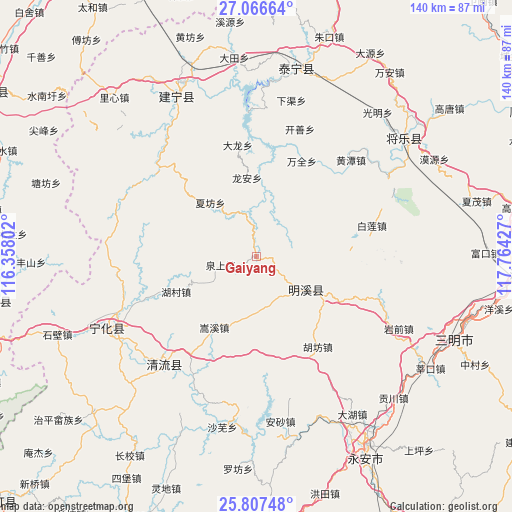
Gaiyang GPS coordinates[2]
26° 26' 19.608" North, 117° 3' 40.104" East
| Map corner | latitude | longitude |
|---|---|---|
| Upper-left | 27.06664°, | 116.35802° |
| Center: | 26.43878°, | 117.06114° |
| Lower-right: | 25.80748°, | 117.76427° |
| Map W x H: | 140×140 km | = 87×87mi |
| max Lat: | 53.31946° ⇑80.7% North |
| Gaiyang: | 26.43878° |
| min Lat: | ⇓19.3% South 18.22056° |
| min Long | Gaiyang | max Long |
| 75.07348° | 117.06114° | 134.28917° |
| W 66.3%⇐ | ⇒33.7% E |
Elevation
Elevation of Gaiyang is 387 m = 1270 ft, and this is 97.8 m = 321 ft below average elevation for this country.
| Max E: |
5622 m = 18445 ft | 31.4% |
| Avg. | 484.8 m = 1591 ft | |
| Gaiyang | 387 m = 1270 ft | |
Min E: |
-3 m = -10 ft | 68.6% |
See also: China elevation on elevation.city.
Geographical zone
Gaiyang is located in North temperate zone (between Tropic of Cancer and the Arctic Circle). Distance of this Northern Tropic circle is 333.8 km =207.4 mi to South.| Distance of | km | miles | from Gaiyang |
|---|---|---|---|
| North Pole | 7067.3 | 4391.4 | to North |
| Arctic Circle | 4461.5 | 2772.2 | to North |
| Tropic Cancer | 333.8 | 207.4 | to South |
| Equator | 2939.7 | 1826.6 | to South |


Nearby cities:
15 places around Gaiyang: (largest is in red/bold)
• Dabu
31 km =19.3 mi,  350°
350°
• Fengxi
22.4 km =13.9 mi,  291°
291°
• Hanxian
24.4 km =15.2 mi,  111°
111°
• Hucun
23.6 km =14.7 mi,  245°
245°
• Hufang
29.7 km =18.5 mi,  145°
145°
• Linshe
13.4 km =8.3 mi,  175°
175°
• Long’an
21.8 km =13.5 mi, 353°
• Quanshang
10.1 km =6.3 mi,  257°
257°
• Shaxi
30.8 km =19.1 mi, 112°
• Shuiqian
31.8 km =19.8 mi,  275°
275°
• Songxi
22.5 km =14 mi,  210°
210°
• Wanquan
28.6 km =17.8 mi,  25°
25°
• Xiafang
19.5 km =12.1 mi,  319°
319°
• Xiaochi
23.2 km =14.4 mi,  190°
190°
• Xuefeng
16.4 km =10.2 mi,  123°
123°
Sources, notices
• [Note1] Compared only with cities in China existing in our database
• [Src1] Map data: © OpenStreetMap contributors (CC-BY-SA)
• [Src2] Other city data from geonames.org with taken over terms of usage.
• [Src3] Geographical zone / Annual Mean Temperature by Robert A. Rohde @ Wikipedia
