Xiafang geodata
Xiafang (Fujian) is a seat of a fourth-order administrative division; located in China in Asia/Shanghai (GMT+8) time zone. In our database, there are 1268 cities with bigger population. Compared to other cities in China, 80.2% of cities are located further ↑North; 65.6% of cities are located further ←West and 69.9% of cities have lower elevation than Xiafang. Note1


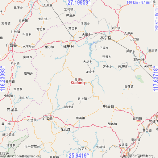
Xiafang GPS coordinates[2]
26° 34' 20.892" North, 116° 56' 2.58" East
| Map corner | latitude | longitude |
|---|---|---|
| Upper-left | 27.19959°, | 116.23093° |
| Center: | 26.57247°, | 116.93405° |
| Lower-right: | 25.9419°, | 117.63718° |
| Map W x H: | 139.8×139.8 km | = 86.9×86.9mi |
| max Lat: | 53.31946° ⇑80.2% North |
| Xiafang: | 26.57247° |
| min Lat: | ⇓19.8% South 18.22056° |
| min Long | Xiafang | max Long |
| 75.07348° | 116.93405° | 134.28917° |
| W 65.6%⇐ | ⇒34.4% E |
Elevation
Elevation of Xiafang is 409 m = 1342 ft, and this is 75.8 m = 249 ft below average elevation for this country.
| Max E: |
5622 m = 18445 ft | 30.1% |
| Avg. | 484.8 m = 1591 ft | |
| Xiafang | 409 m = 1342 ft | |
Min E: |
-3 m = -10 ft | 69.9% |
See also: China elevation on elevation.city.
Geographical zone
Xiafang is located in North temperate zone (between Tropic of Cancer and the Arctic Circle). Distance of this Northern Tropic circle is 348.7 km =216.7 mi to South.| Distance of | km | miles | from Xiafang |
|---|---|---|---|
| North Pole | 7052.5 | 4382.2 | to North |
| Arctic Circle | 4446.6 | 2763 | to North |
| Tropic Cancer | 348.7 | 216.7 | to South |
| Equator | 2954.6 | 1835.9 | to South |


Nearby cities:
15 places around Xiafang: (largest is in red/bold)
• Anyuan
25.7 km =16 mi,  271°
271°
• Dabu
17.4 km =10.8 mi,  25°
25°
• Dushang
22.1 km =13.7 mi,  306°
306°
• Fengxi
10.7 km =6.6 mi,  230°
230°
• Gaiyang
19.5 km =12.1 mi,  139°
139°
• Hedong
30.5 km =19 mi,  343°
343°
• Helong
31.2 km =19.4 mi,  243°
243°
• Hucun
26.2 km =16.3 mi,  199°
199°
• Junkou
16.8 km =10.4 mi,  304°
304°
• Linshe
31.4 km =19.5 mi,  154°
154°
• Long’an
12.1 km =7.5 mi,  55°
55°
• Quanshang
17.3 km =10.7 mi,  170°
170°
• Shuiqian
22.3 km =13.9 mi, 238°
• Suicheng
31.1 km =19.3 mi, 341°
• Wanquan
27.3 km =17 mi,  66°
66°
Sources, notices
• [Note1] Compared only with cities in China existing in our database
• [Src1] Map data: © OpenStreetMap contributors (CC-BY-SA)
• [Src2] Other city data from geonames.org with taken over terms of usage.
• [Src3] Geographical zone / Annual Mean Temperature by Robert A. Rohde @ Wikipedia
