Fujia geodata
Fujia (Gansu) is a seat of a fourth-order administrative division; located in China in Asia/Shanghai (GMT+8) time zone. In our database, there are 1268 cities with bigger population. Compared to other cities in China, 69.3% of cities are located further ↓South; 87% of cities are located further →East and 85.4% of cities have lower elevation than Fujia. Note1


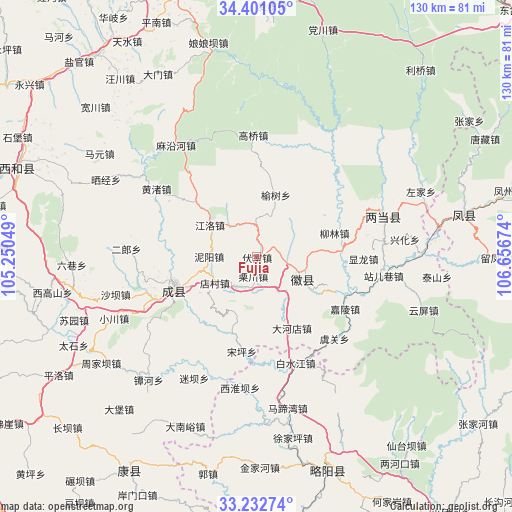
Fujia GPS coordinates[2]
33° 49' 8.004" North, 105° 57' 12.996" East
| Map corner | latitude | longitude |
|---|---|---|
| Upper-left | 34.40105°, | 105.25049° |
| Center: | 33.81889°, | 105.95361° |
| Lower-right: | 33.23274°, | 106.65674° |
| Map W x H: | 129.9×129.9 km | = 80.7×80.7mi |
| max Lat: | 53.31946° ⇑30.7% North |
| Fujia: | 33.81889° |
| min Lat: | ⇓69.3% South 18.22056° |
| min Long | Fujia | max Long |
| 75.07348° | 105.95361° | 134.28917° |
| W 13%⇐ | ⇒87% E |
Elevation
Elevation of Fujia is 1010 m = 3314 ft, and this is 525.2 m = 1723 ft above average elevation for this country.
| Max E: |
5622 m = 18445 ft | 14.6% |
| Fujia | 1010 m 3314 ft | |
| Avg. | 484.8 m = 1591 ft | |
Min E: |
-3 m = -10 ft | 85.4% |
See also: China elevation on elevation.city.
Geographical zone
Fujia is located in North temperate zone (between Tropic of Cancer and the Arctic Circle). Distance of this Northern Tropic circle is 1154.4 km =717.3 mi to South.| Distance of | km | miles | from Fujia |
|---|---|---|---|
| North Pole | 6246.8 | 3881.6 | to North |
| Arctic Circle | 3640.9 | 2262.3 | to North |
| Tropic Cancer | 1154.4 | 717.3 | to South |
| Equator | 3760.3 | 2336.5 | to South |


Nearby cities:
15 places around Fujia: (largest is in red/bold)
• Dahedian
20.4 km =12.7 mi,  154°
154°
• Diancun
13.6 km =8.5 mi,  246°
246°
• Dongguan
14.8 km =9.2 mi,  107°
107°
• Hongchuan
9.6 km =6 mi,  217°
217°
• Huixian Chengguanzhen
13 km =8.1 mi,  115°
115°
• Jiangluo
15.2 km =9.4 mi,  307°
307°
• Liulin
20.9 km =13 mi,  72°
72°
• Nankang
18.9 km =11.7 mi,  199°
199°
• Niyang
12.2 km =7.6 mi,  270°
270°
• Shuiyang
15.9 km =9.9 mi, 119°
• Suchuan
3.4 km =2.1 mi,  187°
187°
• Yinxingshu
7.9 km =4.9 mi,  101°
101°
• Youlongchuan
10.2 km =6.3 mi,  319°
319°
• Yushu
16.4 km =10.2 mi,  17°
17°
• Zhiqi
20.9 km =13 mi, 248°
Sources, notices
• [Note1] Compared only with cities in China existing in our database
• [Src1] Map data: © OpenStreetMap contributors (CC-BY-SA)
• [Src2] Other city data from geonames.org with taken over terms of usage.
• [Src3] Geographical zone / Annual Mean Temperature by Robert A. Rohde @ Wikipedia
