Nankang geodata
Nankang (Gansu) is a seat of a fourth-order administrative division; located in China in Asia/Shanghai (GMT+8) time zone. In our database, there are 1268 cities with bigger population. Compared to other cities in China, 68.6% of cities are located further ↓South; 87.3% of cities are located further →East and 84.4% of cities have lower elevation than Nankang. Note1


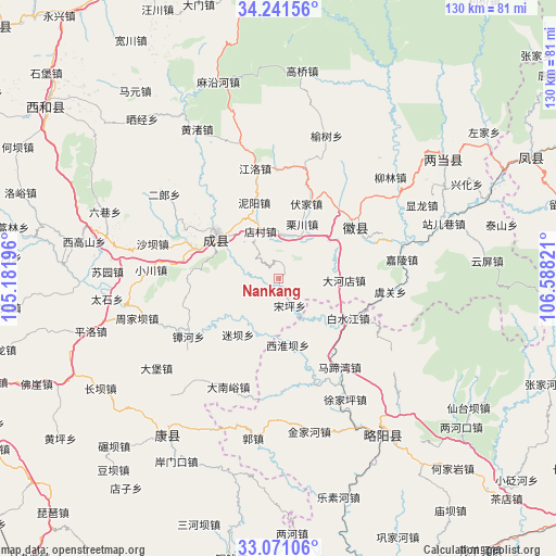
Nankang GPS coordinates[2]
33° 39' 29.88" North, 105° 53' 6.288" East
| Map corner | latitude | longitude |
|---|---|---|
| Upper-left | 34.24156°, | 105.18196° |
| Center: | 33.6583°, | 105.88508° |
| Lower-right: | 33.07106°, | 106.58821° |
| Map W x H: | 130.1×130.1 km | = 80.8×80.8mi |
| max Lat: | 53.31946° ⇑31.4% North |
| Nankang: | 33.6583° |
| min Lat: | ⇓68.6% South 18.22056° |
| min Long | Nankang | max Long |
| 75.07348° | 105.88508° | 134.28917° |
| W 12.7%⇐ | ⇒87.3% E |
Elevation
Elevation of Nankang is 944 m = 3097 ft, and this is 459.2 m = 1507 ft above average elevation for this country.
| Max E: |
5622 m = 18445 ft | 15.6% |
| Nankang | 944 m 3097 ft | |
| Avg. | 484.8 m = 1591 ft | |
Min E: |
-3 m = -10 ft | 84.4% |
See also: China elevation on elevation.city.
Geographical zone
Nankang is located in North temperate zone (between Tropic of Cancer and the Arctic Circle). Distance of this Northern Tropic circle is 1136.5 km =706.2 mi to South.| Distance of | km | miles | from Nankang |
|---|---|---|---|
| North Pole | 6264.6 | 3892.6 | to North |
| Arctic Circle | 3658.7 | 2273.4 | to North |
| Tropic Cancer | 1136.5 | 706.2 | to South |
| Equator | 3742.5 | 2325.5 | to South |


Nearby cities:
15 places around Nankang: (largest is in red/bold)
• Baishuijiang
21.4 km =13.3 mi,  115°
115°
• Chanba
14.4 km =8.9 mi,  234°
234°
• Chengxian Chengguanzhen
17.2 km =10.7 mi,  305°
305°
• Dahedian
15.2 km =9.4 mi,  92°
92°
• Daping
15.3 km =9.5 mi,  266°
266°
• Diancun
14 km =8.7 mi,  333°
333°
• Fujia
18.9 km =11.7 mi,  19°
19°
• Hongchuan
10.3 km =6.4 mi,  2°
2°
• Miba
16 km =9.9 mi,  216°
216°
• Niyang
18.9 km =11.7 mi,  341°
341°
• Paosha
20.7 km =12.9 mi,  290°
290°
• Songping
6.6 km =4.1 mi,  159°
159°
• Suchuan
15.7 km =9.8 mi, 22°
• Xihuaiba
15.1 km =9.4 mi,  168°
168°
• Zhiqi
16.5 km =10.3 mi, 307°
Sources, notices
• [Note1] Compared only with cities in China existing in our database
• [Src1] Map data: © OpenStreetMap contributors (CC-BY-SA)
• [Src2] Other city data from geonames.org with taken over terms of usage.
• [Src3] Geographical zone / Annual Mean Temperature by Robert A. Rohde @ Wikipedia
