Futang geodata
Futang (Guangdong) is a seat of a fourth-order administrative division; located in China in Asia/Shanghai (GMT+8) time zone. In our database, there are 1268 cities with bigger population. Compared to other cities in China, 88.8% of cities are located further ↑North; 62.2% of cities are located further →East and 63.3% of cities have lower elevation than Futang. Note1


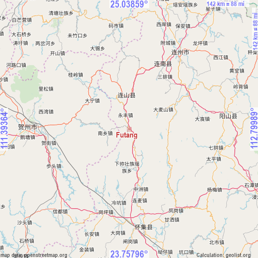
Futang GPS coordinates[2]
24° 23' 59.64" North, 112° 5' 48.336" East
| Map corner | latitude | longitude |
|---|---|---|
| Upper-left | 25.03859°, | 111.39364° |
| Center: | 24.3999°, | 112.09676° |
| Lower-right: | 23.75796°, | 112.79989° |
| Map W x H: | 142.4×142.4 km | = 88.5×88.5mi |
| max Lat: | 53.31946° ⇑88.8% North |
| Futang: | 24.3999° |
| min Lat: | ⇓11.2% South 18.22056° |
| min Long | Futang | max Long |
| 75.07348° | 112.09676° | 134.28917° |
| W 37.8%⇐ | ⇒62.2% E |
Elevation
Elevation of Futang is 302 m = 991 ft, and this is 182.8 m = 600 ft below average elevation for this country.
| Max E: |
5622 m = 18445 ft | 36.7% |
| Avg. | 484.8 m = 1591 ft | |
| Futang | 302 m = 991 ft | |
Min E: |
-3 m = -10 ft | 63.3% |
See also: China elevation on elevation.city.
Geographical zone
Futang is located in North temperate zone (between Tropic of Cancer and the Arctic Circle). Distance of this Northern Tropic circle is 107.1 km =66.5 mi to South.| Distance of | km | miles | from Futang |
|---|---|---|---|
| North Pole | 7294 | 4532.3 | to North |
| Arctic Circle | 4688.2 | 2913.1 | to North |
| Tropic Cancer | 107.1 | 66.5 | to South |
| Equator | 2713 | 1685.8 | to South |


Nearby cities:
15 places around Futang: (largest is in red/bold)
• Dafu
27.8 km =17.3 mi,  351°
351°
• Damaishan
20.1 km =12.5 mi,  60°
60°
• Daping
28.6 km =17.8 mi,  12°
12°
• Jitian
19.3 km =12 mi, 353°
• Libu
36.9 km =22.9 mi, 61°
• Sanpai
34.2 km =21.3 mi,  33°
33°
• Shangshuai
17.6 km =10.9 mi,  200°
200°
• Taibao
32.8 km =20.4 mi, 14°
• Woshui
23.1 km =14.4 mi, 34°
• Xiangping
21.2 km =13.2 mi, 7°
• Xiaosanjiang
14.6 km =9.1 mi,  167°
167°
• Xiashuai
19.7 km =12.2 mi,  186°
186°
• Yonghe
24.9 km =15.5 mi, 345°
• Zhaigang
28.1 km =17.5 mi, 63°
• Zhongzhou
33.4 km =20.8 mi, 168°
Sources, notices
• [Note1] Compared only with cities in China existing in our database
• [Src1] Map data: © OpenStreetMap contributors (CC-BY-SA)
• [Src2] Other city data from geonames.org with taken over terms of usage.
• [Src3] Geographical zone / Annual Mean Temperature by Robert A. Rohde @ Wikipedia
