Yonghe geodata
Yonghe (Guangdong) is a seat of a fourth-order administrative division; located in China in Asia/Shanghai (GMT+8) time zone. In our database, there are 1268 cities with bigger population. Compared to other cities in China, 88% of cities are located further ↑North; 62.6% of cities are located further →East and 63.7% of cities have lower elevation than Yonghe. Note1


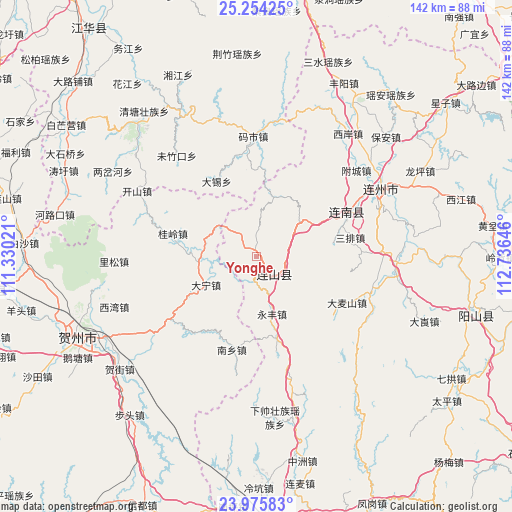
Yonghe GPS coordinates[2]
24° 37' 0.012" North, 112° 1' 59.988" East
| Map corner | latitude | longitude |
|---|---|---|
| Upper-left | 25.25425°, | 111.33021° |
| Center: | 24.61667°, | 112.03333° |
| Lower-right: | 23.97583°, | 112.73646° |
| Map W x H: | 142.1×142.1 km | = 88.3×88.3mi |
| max Lat: | 53.31946° ⇑88% North |
| Yonghe: | 24.61667° |
| min Lat: | ⇓12% South 18.22056° |
| min Long | Yonghe | max Long |
| 75.07348° | 112.03333° | 134.28917° |
| W 37.4%⇐ | ⇒62.6% E |
Elevation
Elevation of Yonghe is 307 m = 1007 ft, and this is 177.8 m = 583 ft below average elevation for this country.
| Max E: |
5622 m = 18445 ft | 36.3% |
| Avg. | 484.8 m = 1591 ft | |
| Yonghe | 307 m = 1007 ft | |
Min E: |
-3 m = -10 ft | 63.7% |
See also: China elevation on elevation.city.
Geographical zone
Yonghe is located in North temperate zone (between Tropic of Cancer and the Arctic Circle). Distance of this Northern Tropic circle is 131.2 km =81.5 mi to South.| Distance of | km | miles | from Yonghe |
|---|---|---|---|
| North Pole | 7269.9 | 4517.3 | to North |
| Arctic Circle | 4664.1 | 2898.1 | to North |
| Tropic Cancer | 131.2 | 81.5 | to South |
| Equator | 2737.1 | 1700.8 | to South |


Nearby cities:
15 places around Yonghe: (largest is in red/bold)
• Dafu
4.1 km =2.5 mi,  33°
33°
• Damaishan
27.8 km =17.3 mi,  120°
120°
• Daping
13.2 km =8.2 mi,  72°
72°
• Futang
24.9 km =15.5 mi,  165°
165°
• Hedong
16.9 km =10.5 mi,  15°
15°
• Jitian
6.5 km =4 mi,  139°
139°
• Jiubei
34.1 km =21.2 mi,  80°
80°
• Lianzhou
38.8 km =24.1 mi,  61°
61°
• Libu
39.4 km =24.5 mi,  99°
99°
• Sanjiang
28.8 km =17.9 mi, 66°
• Sanpai
25.7 km =16 mi, 80°
• Taibao
16.4 km =10.2 mi, 62°
• Woshui
20.1 km =12.5 mi, 104°
• Xiangping
9.6 km =6 mi,  108°
108°
• Zhaigang
33.6 km =20.9 mi, 110°
Sources, notices
• [Note1] Compared only with cities in China existing in our database
• [Src1] Map data: © OpenStreetMap contributors (CC-BY-SA)
• [Src2] Other city data from geonames.org with taken over terms of usage.
• [Src3] Geographical zone / Annual Mean Temperature by Robert A. Rohde @ Wikipedia
