Fenyi geodata
Fenyi (Jiangxi) is a seat of a third-order administrative division; located in China in Asia/Shanghai (GMT+8) time zone. With population of 58,478 people, there are 752 cities with bigger population in this country. Compared to other cities in China, 75.1% of cities are located further ↑North; 52.4% of cities are located further ←West and 62.6% of cities have higher elevation than Fenyi. Note1


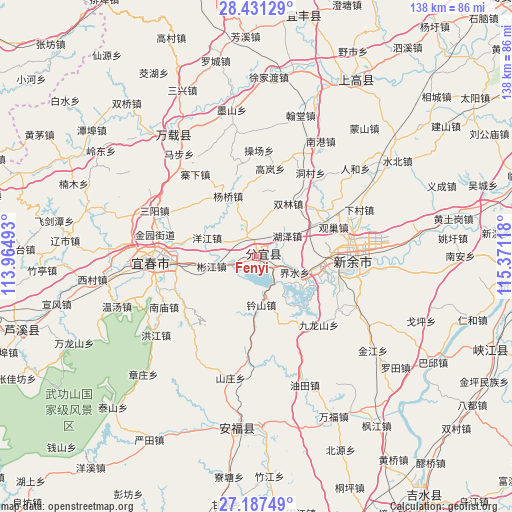
Fenyi GPS coordinates[2]
27° 48' 40.212" North, 114° 40' 4.98" East
| Map corner | latitude | longitude |
|---|---|---|
| Upper-left | 28.43129°, | 113.96493° |
| Center: | 27.81117°, | 114.66805° |
| Lower-right: | 27.18749°, | 115.37118° |
| Map W x H: | 138.3×138.3 km | = 85.9×85.9mi |
| max Lat: | 53.31946° ⇑75.1% North |
| Fenyi: | 27.81117° |
| min Lat: | ⇓24.9% South 18.22056° |
| min Long | Fenyi | max Long |
| 75.07348° | 114.66805° | 134.28917° |
| W 52.4%⇐ | ⇒47.6% E |
Elevation
Elevation of Fenyi is 84 m = 276 ft, and this is 400.8 m = 1315 ft below average elevation for this country.
| Max E: |
5622 m = 18445 ft | 62.6% |
| Avg. | 484.8 m = 1591 ft | |
| Fenyi | 84 m = 276 ft | |
Min E: |
-3 m = -10 ft | 37.4% |
See also: Fenyi elevation on elevation.city.
Geographical zone
Fenyi is located in North temperate zone (between Tropic of Cancer and the Arctic Circle). Distance of this Northern Tropic circle is 486.4 km =302.2 mi to South.| Distance of | km | miles | from Fenyi |
|---|---|---|---|
| North Pole | 6914.7 | 4296.6 | to North |
| Arctic Circle | 4308.9 | 2677.4 | to North |
| Tropic Cancer | 486.4 | 302.2 | to South |
| Equator | 3092.3 | 1921.5 | to South |


Nearby cities:
15 places around Fenyi: (largest is in red/bold)
• Binjiang
11.8 km =7.3 mi,  255°
255°
• Dagangshan
19 km =11.8 mi,  204°
204°
• Fengyang
6.1 km =3.8 mi,  334°
334°
• Guanchao
21 km =13 mi,  66°
66°
• Hexia
17.9 km =11.1 mi,  96°
96°
• Huze
10.1 km =6.3 mi,  53°
53°
• Jieshui
9.4 km =5.8 mi,  107°
107°
• Ouli
20.7 km =12.9 mi, 51°
• Shuanglin
16.7 km =10.4 mi,  30°
30°
• Songshan
19.9 km =12.4 mi,  182°
182°
• Xinyu
17.8 km =11.1 mi,  79°
79°
• Xinzhi
13 km =8.1 mi,  173°
173°
• Yangjiang
14.1 km =8.8 mi,  290°
290°
• Yangqiao
18 km =11.2 mi, 334°
• Yuankeng
19 km =11.8 mi,  162°
162°
Sources, notices
• [Note1] Compared only with cities in China existing in our database
• [Src1] Map data: © OpenStreetMap contributors (CC-BY-SA)
• [Src2] Other city data from geonames.org with taken over terms of usage.
• [Src3] Geographical zone / Annual Mean Temperature by Robert A. Rohde @ Wikipedia
